IMAGES TAKEN NEAR TO
Hamsteels Lane, DURHAM, DH7 9RS
Introduction
This page details the photographs taken nearby to Hamsteels Lane, DH7 9RS by members of the Geograph project.
The Geograph project started in 2005 with the aim of publishing, organising and preserving representative images for every square kilometre of Great Britain, Ireland and the Isle of Man.

There are currently over 7.5m images from over14,400 individuals and you can help contribute to the project by visiting https://www.geograph.org.uk
Image Map
Images are licensed for reuse under creativecommons.org/licenses/by-sa/2.0
Notes
- Clicking on the map will re-center to the selected point.
- The higher the marker number, the further away the image location is from the centre of the postcode.
Image Listing (7 Images Found)
Images are licensed for reuse under creativecommons.org/licenses/by-sa/2.0
Image
Details
Distance
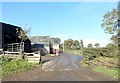
1
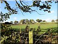
Malton House farm
Viewed from the east on Hamsteels Lane. The usual mixture for farms in this area of C19 and C20 buildings.
Image: © Robert Graham
Taken: 25 Oct 2016
0.02 miles
2
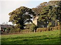
Old farmhouse at Malton House
Viewed from Hamsteels Lane. Although it's a bit difficult to make out from this shot, this is a most unusual type of farmhouse, comprising two houses back to back.
Image: © Robert Graham
Taken: 25 Oct 2016
0.02 miles
3
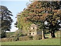
Old byre at Malton House
Viewed from Hamsteels Lane. This is a very common type of farm building from the late C18 or early C19 to house cattle below with hay storage above.
Image: © Robert Graham
Taken: 25 Oct 2016
0.03 miles
4
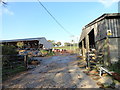
Farmyard at Malton House Farm
Looking north from Hamsteels Lane. From the look of the cows, this is a dairy farm. They seem to be Frisians, the usual dairy breed.
Image: © Robert Graham
Taken: 25 Oct 2016
0.04 miles
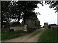
5
Entrance to Malton House Farm
Old C19 farmstead on the north side of Hamsteels Bank, south of Lanchester. The farmhouse is at the top of the drive.
Image: © Robert Graham
Taken: 25 Oct 2016
0.04 miles
7

View to the north near Quebec
Taken from the path over the fields north of the village. I was a bit puzzled by the lovely drystone wall. There were no others in the area, and a barbed wire fence would have seemed the obvious alternative, and far cheaper.
Image: © Robert Graham
Taken: 15 Aug 2012
0.24 miles