IMAGES TAKEN NEAR TO
Hill Top, DURHAM, DH7 9RN
Introduction
This page details the photographs taken nearby to Hill Top, DH7 9RN by members of the Geograph project.
The Geograph project started in 2005 with the aim of publishing, organising and preserving representative images for every square kilometre of Great Britain, Ireland and the Isle of Man.

There are currently over 7.5m images from over14,400 individuals and you can help contribute to the project by visiting https://www.geograph.org.uk
Image Map
Images are licensed for reuse under creativecommons.org/licenses/by-sa/2.0
Notes
- Clicking on the map will re-center to the selected point.
- The higher the marker number, the further away the image location is from the centre of the postcode.
Image Listing (4 Images Found)
Images are licensed for reuse under creativecommons.org/licenses/by-sa/2.0
Image
Details
Distance
1
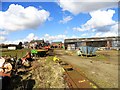
Esh Hill Top Farm
This farm is actually in Langley Park. A wonderful collection of machinery lying about.
Image: © Robert Graham
Taken: 3 Apr 2013
0.03 miles
2
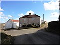
Top of the bank
This house stands right on the hairpin bend of the road leading up from Langley Park to the top of the steep escarpement behind the village.
Image: © Robert Graham
Taken: 3 Apr 2013
0.10 miles
3
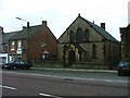
St Andrew's Methodist Chapel, Langley Park
Image: © Mick Garratt
Taken: 23 Jul 2005
0.20 miles
4
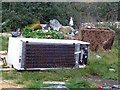
Fly Tipping
North East Waste Services. For All Your Fly Tipping Needs.
Image: © Juliane Savage
Taken: 1 Jan 2016
0.24 miles