IMAGES TAKEN NEAR TO
Hill Top, DURHAM, DH7 9RL
Introduction
This page details the photographs taken nearby to Hill Top, DH7 9RL by members of the Geograph project.
The Geograph project started in 2005 with the aim of publishing, organising and preserving representative images for every square kilometre of Great Britain, Ireland and the Isle of Man.

There are currently over 7.5m images from over14,400 individuals and you can help contribute to the project by visiting https://www.geograph.org.uk
Image Map
Images are licensed for reuse under creativecommons.org/licenses/by-sa/2.0
Notes
- Clicking on the map will re-center to the selected point.
- The higher the marker number, the further away the image location is from the centre of the postcode.
Image Listing (11 Images Found)
Images are licensed for reuse under creativecommons.org/licenses/by-sa/2.0
Image
Details
Distance
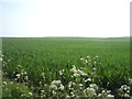
1
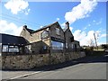
New Board Inn at Langley Park
This pub is situated on top of the escarpment just south of the village and has fantastic views over the Browney valley.
Image: © Robert Graham
Taken: 3 Apr 2013
0.05 miles
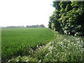
2

The Board Inn
Field and wooded area to the rear of the Board Inn pub.
Image: © Antonia
Taken: 28 Jun 2008
0.07 miles
3
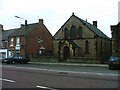
St Andrew's Methodist Chapel, Langley Park
Image: © Mick Garratt
Taken: 23 Jul 2005
0.09 miles
4
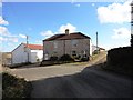
Top of the bank
This house stands right on the hairpin bend of the road leading up from Langley Park to the top of the steep escarpement behind the village.
Image: © Robert Graham
Taken: 3 Apr 2013
0.15 miles
5
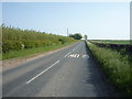
Heading south from Hill Top
Towards Ushaw Farm.
Image: © JThomas
Taken: 4 Jun 2016
0.15 miles
7
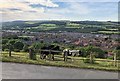
Langley Park
Looking down on Langley Park from near the car park of the New Board Inn.
Image: © Chris Thomas-Atkin
Taken: 23 Jun 2018
0.16 miles
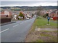
9
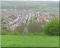
Langley Park seen from Hill Top
The road in centre of image is Front Street
Image: © Peter Robinson
Taken: 12 May 2013
0.20 miles
10
Front Street, Langley Park
Rising steeply up from the valley of the River Browney.
Image: © Oliver Dixon
Taken: 15 Mar 2013
0.23 miles