IMAGES TAKEN NEAR TO
Esh, DURHAM, DH7 9RE
Introduction
This page details the photographs taken nearby to DH7 9RE by members of the Geograph project.
The Geograph project started in 2005 with the aim of publishing, organising and preserving representative images for every square kilometre of Great Britain, Ireland and the Isle of Man.

There are currently over 7.5m images from over14,400 individuals and you can help contribute to the project by visiting https://www.geograph.org.uk
Image Map
Images are licensed for reuse under creativecommons.org/licenses/by-sa/2.0
Notes
- Clicking on the map will re-center to the selected point.
- The higher the marker number, the further away the image location is from the centre of the postcode.
Image Listing (5 Images Found)
Images are licensed for reuse under creativecommons.org/licenses/by-sa/2.0
Image
Details
Distance
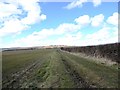
4
Heading south from Hill Top
Towards Ushaw Farm.
Image: © JThomas
Taken: 4 Jun 2016
0.21 miles
5
View west along the field path
Looking along the path leading west from the road at Millgate Cottages. The village of Esh on the horizon.
Image: © Robert Graham
Taken: 3 Apr 2013
0.22 miles