IMAGES TAKEN NEAR TO
Esh, DURHAM, DH7 9RA
Introduction
This page details the photographs taken nearby to DH7 9RA by members of the Geograph project.
The Geograph project started in 2005 with the aim of publishing, organising and preserving representative images for every square kilometre of Great Britain, Ireland and the Isle of Man.

There are currently over 7.5m images from over14,400 individuals and you can help contribute to the project by visiting https://www.geograph.org.uk
Image Map
Images are licensed for reuse under creativecommons.org/licenses/by-sa/2.0
Notes
- Clicking on the map will re-center to the selected point.
- The higher the marker number, the further away the image location is from the centre of the postcode.
Image Listing (17 Images Found)
Images are licensed for reuse under creativecommons.org/licenses/by-sa/2.0
Image
Details
Distance
1
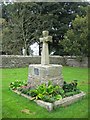
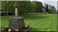
Old Central Cross by Hall Road, Esh Parish
Esh Village Cross, old head and base in a new cross by the UC road, in parish of Esh (Derwentside District), Esh Village Cross, on open grass, West side of Hall Road.
Grade II listed. List Entry Number: 1185955
https://historicengland.org.uk/listing/the-list/list-entry/1185955
Scheduled Monument. List Entry Number: 1016487
https://historicengland.org.uk/listing/the-list/list-entry/1016487
To be surveyed
Milestone Society National ID: DUDS_ESH
Image: © Milestone Society
Taken: Unknown
0.11 miles
3
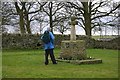
Esh Cross and Village Green
This cross was restored in 1999 by the stonemason David Edwick. The shaft has clearly been replaced and the engraving on the attached metal plate tells that the remnants of the original may be seen in the church, which is beyond the distant stone wall.
Image: © Trevor Littlewood
Taken: 8 May 2010
0.12 miles
6
Esh Cross
Erected in 1687, Esh Cross stands on the site of an earlier medieval structure. Its origins are religious significance rather than as a market cross.
Image: © Uncredited
Taken: 16 Mar 2005
0.16 miles
7
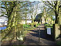
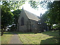
St Michael's and All Angels Church, Esh
Dating back to the 13th century. Stands in the attractive village of Esh on top of a steep ridge overlooking the Browney Valley
Image: © Oliver Dixon
Taken: 3 Apr 2006
0.16 miles
8
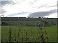
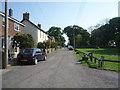
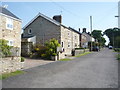
Esh village
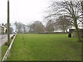
Esh village stands at the top of a steep escarpment overlooking the Browney valley. Here seen from the old Lanchester railway path with a dramatic sky as backdrop.
Image: © Oliver Dixon
Taken: 12 Nov 2006
0.16 miles