IMAGES TAKEN NEAR TO
Esh Winning, DURHAM, DH7 9PZ
Introduction
This page details the photographs taken nearby to DH7 9PZ by members of the Geograph project.
The Geograph project started in 2005 with the aim of publishing, organising and preserving representative images for every square kilometre of Great Britain, Ireland and the Isle of Man.

There are currently over 7.5m images from over14,400 individuals and you can help contribute to the project by visiting https://www.geograph.org.uk
Image Map
Images are licensed for reuse under creativecommons.org/licenses/by-sa/2.0
Notes
- Clicking on the map will re-center to the selected point.
- The higher the marker number, the further away the image location is from the centre of the postcode.
Image Listing (6 Images Found)
Images are licensed for reuse under creativecommons.org/licenses/by-sa/2.0
Image
Details
Distance
1
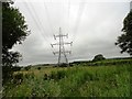
Pylons from the Deerness Valley Walk
Looking north from east of Esh Winning.
Image: © Robert Graham
Taken: 10 Jul 2013
0.12 miles
2
View of Flass Terrace
A little terrace east of the village of Esh Winning. Viewed from the Deerness Valley Walk which passes to the south. The name comes from the nearby Flass Hall, a manor house dating back to the 16th century.
Image: © Robert Graham
Taken: 10 Jul 2013
0.14 miles
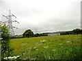
3
Field in valley of River Deerness
East of Esh Winning there's new housing alongside the B6302; this image was recorded at the east end of the houses and shows the view out beyond a field, over the Deerness Valley to woodland on its south side.
Image: © Trevor Littlewood
Taken: 6 Oct 2012
0.17 miles
4
Confluence near Esh Winning
Where the Hedleyhope Burn (to the left) joins the River Deerness.
Image: © Oliver Dixon
Taken: 15 Mar 2013
0.18 miles
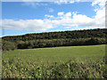
5
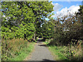
Deerness Valley Walk
The Deerness Valley Walk looking north-east from east of Esh Winning.
Image: © Trevor Littlewood
Taken: 6 Oct 2012
0.19 miles
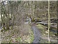
6
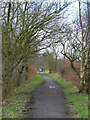
Deerness Valley Path, near Esh Winning
One of the many disused railways in County Durham which has been converted into a pedestrian and cycle path
Image: © Oliver Dixon
Taken: 3 Apr 2006
0.21 miles