IMAGES TAKEN NEAR TO
Hawthorne Close, DURHAM, DH7 9FD
Introduction
This page details the photographs taken nearby to Hawthorne Close, DH7 9FD by members of the Geograph project.
The Geograph project started in 2005 with the aim of publishing, organising and preserving representative images for every square kilometre of Great Britain, Ireland and the Isle of Man.

There are currently over 7.5m images from over14,400 individuals and you can help contribute to the project by visiting https://www.geograph.org.uk
Image Map
Images are licensed for reuse under creativecommons.org/licenses/by-sa/2.0
Notes
- Clicking on the map will re-center to the selected point.
- The higher the marker number, the further away the image location is from the centre of the postcode.
Image Listing (13 Images Found)
Images are licensed for reuse under creativecommons.org/licenses/by-sa/2.0
Image
Details
Distance
1
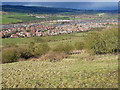
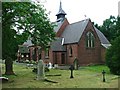
Langley Park
A commanding view from Esh village down into the Browney valley
Image: © Oliver Dixon
Taken: 3 Apr 2006
0.04 miles
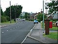
2
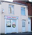
Yummy Yummy Chinese takeaway
Had to snap this one - just because of the name.
Image: © David Clark
Taken: 1 Apr 2010
0.06 miles
3
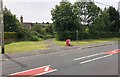
Path to Esh
The footpath leaving Langley Park and heading to the village of Esh.
Image: © Chris Thomas-Atkin
Taken: 23 Jun 2018
0.08 miles
4
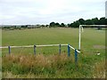
Langley Park FC
It seems appropriate to include this photo because Langley Park was the birthplace of Sir Bobby Robson one time England manager, and now Newcastle United. Although I have no evidence he actually played here in his youth.
Image: © Mick Garratt
Taken: 23 Jul 2005
0.15 miles
5
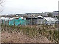
Allotments at Langley Park
These allotments are dominated by sheds and seem to be given over to poultry and livestock rearing; there doesn't seem to be much cultivation taking place.
Image: © Oliver Dixon
Taken: 15 Mar 2013
0.18 miles
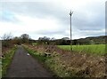
6
View along the Lancheater Railway Walk
Looking east along the former railway near Langley Park in winter.
Image: © Robert Graham
Taken: 21 Feb 2022
0.19 miles
7
Seat beside the railway walk
Looking west along the Lanchester Valley Walk beside Langley Park.
Image: © Robert Graham
Taken: 21 Feb 2022
0.19 miles
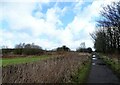
8
Low Moor Road, Langley Park
Looking west towards the edge of the former mining community.
Image: © Mick Garratt
Taken: 23 Jul 2005
0.20 miles
10
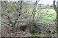
Culvert under the farm track
In a field beside the Lanchester Valley Walk at Langley Park. A drainage ditch leading down to the nearby River Browney.
Image: © Robert Graham
Taken: 21 Feb 2022
0.21 miles