IMAGES TAKEN NEAR TO
Cornsay, DURHAM, DH7 9ER
Introduction
This page details the photographs taken nearby to DH7 9ER by members of the Geograph project.
The Geograph project started in 2005 with the aim of publishing, organising and preserving representative images for every square kilometre of Great Britain, Ireland and the Isle of Man.

There are currently over 7.5m images from over14,400 individuals and you can help contribute to the project by visiting https://www.geograph.org.uk
Image Map
Images are licensed for reuse under creativecommons.org/licenses/by-sa/2.0
Notes
- Clicking on the map will re-center to the selected point.
- The higher the marker number, the further away the image location is from the centre of the postcode.
Image Listing (7 Images Found)
Images are licensed for reuse under creativecommons.org/licenses/by-sa/2.0
Image
Details
Distance
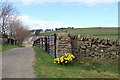
2
Cowsley Lane at the entrance to Lodge House Farm
Looking north-eastward.
Image: © Peter Wood
Taken: 31 Mar 2017
0.07 miles
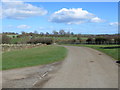
3
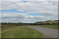
Grassland near Lodge House Farm
Off Cowsley Lane.
Image: © JThomas
Taken: 27 Aug 2018
0.09 miles
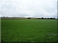
4
Field entrance and footpath off Cowsley Lane
Image: © JThomas
Taken: 27 Aug 2018
0.10 miles
6
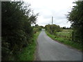
Cowsley Lane
Looking north east uphill towards a junction.
Image: © JThomas
Taken: 27 Aug 2018
0.13 miles
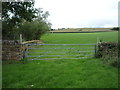
7
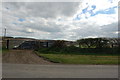
Fields backing on to moorland below Hedley Hill
Image: © P Glenwright
Taken: 11 Apr 2007
0.17 miles