IMAGES TAKEN NEAR TO
Cornsay Colliery, DURHAM, DH7 9EB
Introduction
This page details the photographs taken nearby to DH7 9EB by members of the Geograph project.
The Geograph project started in 2005 with the aim of publishing, organising and preserving representative images for every square kilometre of Great Britain, Ireland and the Isle of Man.

There are currently over 7.5m images from over14,400 individuals and you can help contribute to the project by visiting https://www.geograph.org.uk
Image Map (Loading...)


Getting Data...Please wait
Leaflet Map data © OpenStreetMap
Images are licensed for reuse under creativecommons.org/licenses/by-sa/2.0
Notes
- Clicking on the map will re-center to the selected point.
- The higher the marker number, the further away the image location is from the centre of the postcode.
Image Listing (13 Images Found)
Images are licensed for reuse under creativecommons.org/licenses/by-sa/2.0
Image
Details
Distance
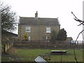
2
Rowley farmhouse
This fine old stone farmhouse is probably early or mid Victorian. The farm itself is older than that, there was a medieval village here. An interesting point is the inscribed stone between the upper windows. The initials E S on the lower line stand for Edward Smythe, a local land owner who put these plaques on all his tenant farms. I was kindly given this information by the present farmer.
Image: © Robert Graham
Taken: 6 Jul 2016
0.03 miles
3
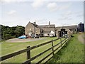
Rowley Farm from the east
This nice old farmstead stands in the fields west of Esh Winning village. The present buildings here are probably mid Victorian, but the farm itself is older than that. There was a medieval village here called West Rowley, so it's probable that there has been a farm of some sort on this site since then.
Image: © Robert Graham
Taken: 6 Jul 2016
0.03 miles

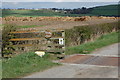
5
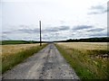
Looking east down the track to Rowley Farm
This track leads to the farm from the B6302 south of Cornsay Colliery.
Image: © Robert Graham
Taken: 6 Jul 2016
0.13 miles
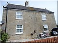
6
Entrance to Rowley Farm near Cornsay Colliery
Image: © P Glenwright
Taken: 11 Apr 2007
0.14 miles
7
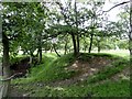
Moat at Castle Steads, Esh Winning
This site to the west of the present village was the location of a medieval manor house. Built in the C12, it was abandoned in the mid C17. Nothing much remains, but the moat, now dry, is still very prominent. This is the SW corner.
Image: © Robert Graham
Taken: 6 Jul 2016
0.15 miles
8
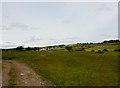
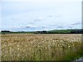
View across to the ridge top
Looking west from north of Rowley Farm. The former mining village of Cornsay Colliery in the distance and the top of the ridge to the right.
Image: © Robert Graham
Taken: 6 Jul 2016
0.16 miles
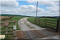
10
View north from the track to Rowley Farm
The farm outbuildings can be seen on the right. On the far horizon in the centre is Quebec village, with Cliffords House Farm in front.
Image: © Robert Graham
Taken: 6 Jul 2016
0.17 miles