IMAGES TAKEN NEAR TO
Quebec, DURHAM, DH7 9DJ
Introduction
This page details the photographs taken nearby to DH7 9DJ by members of the Geograph project.
The Geograph project started in 2005 with the aim of publishing, organising and preserving representative images for every square kilometre of Great Britain, Ireland and the Isle of Man.

There are currently over 7.5m images from over14,400 individuals and you can help contribute to the project by visiting https://www.geograph.org.uk
Image Map
Images are licensed for reuse under creativecommons.org/licenses/by-sa/2.0
Notes
- Clicking on the map will re-center to the selected point.
- The higher the marker number, the further away the image location is from the centre of the postcode.
Image Listing (6 Images Found)
Images are licensed for reuse under creativecommons.org/licenses/by-sa/2.0
Image
Details
Distance
1
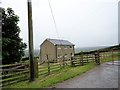
The farmhouse at Heugh farm
This farm is a short distance north of Esh Winning. As can be seen, it is on top of the ridge overlooking the village. Although the farm dates back at least to the early C19, the farmhouse is a C20 rebuild.
Image: © Robert Graham
Taken: 29 Jun 2016
0.05 miles
3
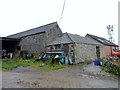
Old outbuildings at Heugh farm
This farm is a short distance north of Esh Winning. It was here before the village, which was built as a mining settlement in the mid C19. The farm is shown on the 1861 First Series Ordnance Survey map, and was probably built some time before that. Many of the older buildings have gone, but these stone built ones look as though they date from the original farm.
Image: © Robert Graham
Taken: 29 Jun 2016
0.06 miles
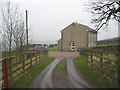
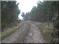
4
Track running west from Heugh farm
Although you never think it, this was once the Roman road of Dere Street.
Image: © Robert Graham
Taken: 29 Jun 2016
0.07 miles
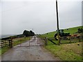
6
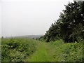
View south along the edge of Heugh Wood
View from below Heugh farm, at Esh Winning. The south slope of the Deerness valley in the distance.
Image: © Robert Graham
Taken: 29 Jun 2016
0.19 miles