IMAGES TAKEN NEAR TO
The Paddock, DURHAM, DH7 9AW
Introduction
This page details the photographs taken nearby to The Paddock, DH7 9AW by members of the Geograph project.
The Geograph project started in 2005 with the aim of publishing, organising and preserving representative images for every square kilometre of Great Britain, Ireland and the Isle of Man.

There are currently over 7.5m images from over14,400 individuals and you can help contribute to the project by visiting https://www.geograph.org.uk
Image Map
Images are licensed for reuse under creativecommons.org/licenses/by-sa/2.0
Notes
- Clicking on the map will re-center to the selected point.
- The higher the marker number, the further away the image location is from the centre of the postcode.
Image Listing (13 Images Found)
Images are licensed for reuse under creativecommons.org/licenses/by-sa/2.0
Image
Details
Distance
1
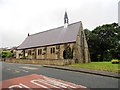
View of St Paul's church, Waterhouses
Parish church for this ex mining village near Esh Winning.
Image: © Robert Graham
Taken: 10 Jul 2013
0.06 miles
2
Deerness Valley Path at Waterhouses
Looking west. One of the many disused railways in County Durham which has been converted into an attractive path for walkers and cyclists
Image: © Oliver Dixon
Taken: 3 Apr 2006
0.07 miles
3
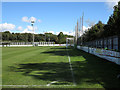
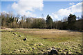
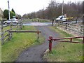
Esh Winning Football Club - the pitch
The southern end of Esh Winning Football Club's pitch is seen here; it lies away from the village and adjacent to The Deerness Valley Walk, which runs along the route of an old railway.
Image: © Trevor Littlewood
Taken: 6 Oct 2012
0.08 miles
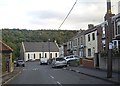
4
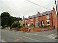
Russell Street, Waterhouses
Looking west. The large stone building is (or was) the vicarage. Waterhouses is a former mining village near Esh Winning.
Image: © Robert Graham
Taken: 10 Jul 2013
0.13 miles
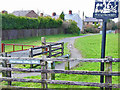
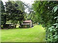
5
The visitors' car park at Esh Winning Football Club
The roughly grassed area of ground that signs indicate to be the visitors' parking area.
Image: © Trevor Littlewood
Taken: 12 Mar 2021
0.13 miles
6
Outbuildings in a garden at Waterhouses
Off Russel Street in this former mining village. Don't know what the brick building was originally. It may have been a farm building of some sort.
Image: © Robert Graham
Taken: 10 Jul 2013
0.13 miles
7
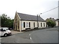
Former chapel in Waterhouses
Now a garage, at better use than falling derelict or being demolished. At this point, Russell Street, the main road through the village, kinks to the north.
Image: © Robert Graham
Taken: 10 Jul 2013
0.19 miles
8
Russell Street, Waterhouses
The former chapel at a bend in the road ahead is now a vehicle MOT centre.
Image: © Stanley Howe
Taken: 21 Sep 2013
0.20 miles
9
Crossing on the Deerness Valley Railway Path
This path, one of many railway paths in County Durham, follows the line of an old railway from Durham to Crook. The railway was opened in 1858, closed to passengers in 1951 and finally closed in 1964.
Image: © Oliver Dixon
Taken: 15 Mar 2013
0.22 miles
10
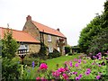
High Waterhouses Farm
A very nice garden at this restored old farmhouse. Not a working farm any longer I don't think.
Image: © Robert Graham
Taken: 10 Jul 2013
0.22 miles