IMAGES TAKEN NEAR TO
Brancepeth, DURHAM, DH7 8EF
Introduction
This page details the photographs taken nearby to DH7 8EF by members of the Geograph project.
The Geograph project started in 2005 with the aim of publishing, organising and preserving representative images for every square kilometre of Great Britain, Ireland and the Isle of Man.

There are currently over 7.5m images from over14,400 individuals and you can help contribute to the project by visiting https://www.geograph.org.uk
Image Map
Images are licensed for reuse under creativecommons.org/licenses/by-sa/2.0
Notes
- Clicking on the map will re-center to the selected point.
- The higher the marker number, the further away the image location is from the centre of the postcode.
Image Listing (7 Images Found)
Images are licensed for reuse under creativecommons.org/licenses/by-sa/2.0
Image
Details
Distance
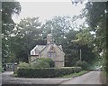
1
Minor road passing Tudhoe Lodge
The road is Scripton Lane; it's seen heading north towards the A689 which it will join north-east of Brancepeth.
Image: © Trevor Littlewood
Taken: 7 Feb 2016
0.01 miles
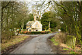
4
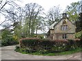
Tudhoe Lodge, Scripton Lane
A lodge entrance into Brancepeth Park (Brancepeth Castle Image). The name "Tudhoe" refers to the fact that there was once a way through from Tudhoe over a long-abandoned ford on the River Wear.
Image: © Oliver Dixon
Taken: 16 Apr 2007
0.02 miles
5
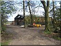
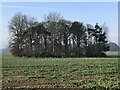
Barn in the trees, Tudhoe Lodge
Off Scripton Lane.
Image: © Oliver Dixon
Taken: 16 Apr 2007
0.03 miles
6
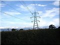
An electricity pylon near Tudhoe Lodge
Viewed from Scripton Lane.
Image: © Stanley Howe
Taken: 21 Sep 2013
0.06 miles