IMAGES TAKEN NEAR TO
Morley Lane, DURHAM, DH7 8DS
Introduction
This page details the photographs taken nearby to Morley Lane, DH7 8DS by members of the Geograph project.
The Geograph project started in 2005 with the aim of publishing, organising and preserving representative images for every square kilometre of Great Britain, Ireland and the Isle of Man.

There are currently over 7.5m images from over14,400 individuals and you can help contribute to the project by visiting https://www.geograph.org.uk
Image Map
Images are licensed for reuse under creativecommons.org/licenses/by-sa/2.0
Notes
- Clicking on the map will re-center to the selected point.
- The higher the marker number, the further away the image location is from the centre of the postcode.
Image Listing (3 Images Found)
Images are licensed for reuse under creativecommons.org/licenses/by-sa/2.0
Image
Details
Distance
1
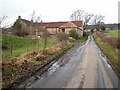
Morley Farm, Brancepeth
On the way up to Pithouse Plantation.
Image: © Oliver Dixon
Taken: 23 Feb 2007
0.01 miles
2
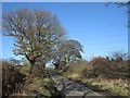
Morley Lane north of Morley Farm
A narrow, minor road known as Morley Lane, lined with unkempt hedges.
Image: © Trevor Littlewood
Taken: 2 Feb 2014
0.15 miles
3
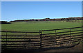
Field with ill-fitting gates
The field with an emerging crop lies on the north-west side of a minor road known as Morley Lane.
Image: © Trevor Littlewood
Taken: 2 Feb 2014
0.23 miles