IMAGES TAKEN NEAR TO
New Acres, DURHAM, DH7 7RX
Introduction
This page details the photographs taken nearby to New Acres, DH7 7RX by members of the Geograph project.
The Geograph project started in 2005 with the aim of publishing, organising and preserving representative images for every square kilometre of Great Britain, Ireland and the Isle of Man.

There are currently over 7.5m images from over14,400 individuals and you can help contribute to the project by visiting https://www.geograph.org.uk
Image Map
Images are licensed for reuse under creativecommons.org/licenses/by-sa/2.0
Notes
- Clicking on the map will re-center to the selected point.
- The higher the marker number, the further away the image location is from the centre of the postcode.
Image Listing (14 Images Found)
Images are licensed for reuse under creativecommons.org/licenses/by-sa/2.0
Image
Details
Distance
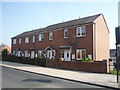
1
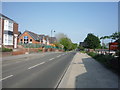
School on Durham Road, Ushaw Moor
This is the main route eastwards to Durham City from the village centre.
Image: © Robert Graham
Taken: 10 Jul 2013
0.17 miles
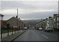
2
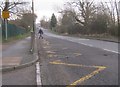
Broom Lane (B6302), Ushaw Moor
Looking south east.
Image: © JThomas
Taken: 4 Jun 2016
0.17 miles
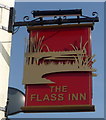
6
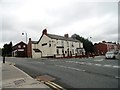
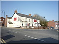
The Flass, Ushaw Moor
Pub in the centre of the village, which takes its name from the ancient manor of Flass Hall nearby.
Image: © Robert Graham
Taken: 10 Jul 2013
0.21 miles
7
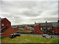
View south from Durham Road, Ushaw Moor
Showing typical 19th century pit village houses, and a nice view over the Deerness valley beyond.
Image: © Robert Graham
Taken: 10 Jul 2013
0.22 miles
9
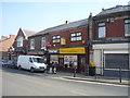
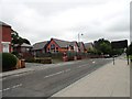
Convenience store, Ushaw Moor
On Broom Lane.
Image: © JThomas
Taken: 4 Jun 2016
0.22 miles