IMAGES TAKEN NEAR TO
Braunespath Estate, DURHAM, DH7 7JG
Introduction
This page details the photographs taken nearby to Braunespath Estate, DH7 7JG by members of the Geograph project.
The Geograph project started in 2005 with the aim of publishing, organising and preserving representative images for every square kilometre of Great Britain, Ireland and the Isle of Man.

There are currently over 7.5m images from over14,400 individuals and you can help contribute to the project by visiting https://www.geograph.org.uk
Image Map (Loading...)


Getting Data...Please wait
Leaflet Map data © OpenStreetMap
Images are licensed for reuse under creativecommons.org/licenses/by-sa/2.0
Notes
- Clicking on the map will re-center to the selected point.
- The higher the marker number, the further away the image location is from the centre of the postcode.
Image Listing (2 Images Found)
Images are licensed for reuse under creativecommons.org/licenses/by-sa/2.0
Image
Details
Distance
1
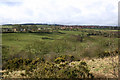
New Brancepeth, seen from the Deerness Valley Walk
New Brancepeth as seen from the disused railway track now known as the Deerness Valley Walk.
Image: © Uncredited
Taken: 16 Mar 2005
0.07 miles
2
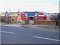
New Brancepeth Village Hall
New Brancepeth is a former coalmining village; quite different from Old Brancepeth on the other side of the hill, which is a very genteel sort of place
Image: © Oliver Dixon
Taken: 3 Apr 2006
0.18 miles