IMAGES TAKEN NEAR TO
New Brancepeth, DURHAM, DH7 7HJ
Introduction
This page details the photographs taken nearby to DH7 7HJ by members of the Geograph project.
The Geograph project started in 2005 with the aim of publishing, organising and preserving representative images for every square kilometre of Great Britain, Ireland and the Isle of Man.

There are currently over 7.5m images from over14,400 individuals and you can help contribute to the project by visiting https://www.geograph.org.uk
Image Map
Images are licensed for reuse under creativecommons.org/licenses/by-sa/2.0
Notes
- Clicking on the map will re-center to the selected point.
- The higher the marker number, the further away the image location is from the centre of the postcode.
Image Listing (5 Images Found)
Images are licensed for reuse under creativecommons.org/licenses/by-sa/2.0
Image
Details
Distance
1
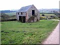
Old barn at Hill House Farm, Esh Winning
Pithouse Hill Image on the skyline.
Image: © Oliver Dixon
Taken: 23 Feb 2007
0.01 miles
3
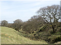
Stream groove descending towards Esh Wood
Esh Wood, close to the village of Esh Winning, lies beyond the nearer trees lining the stream.
Image: © Trevor Littlewood
Taken: 22 Mar 2015
0.08 miles
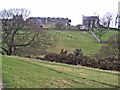
5
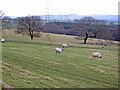
Pasture land above Esh Wood
Esh village Image can be seen at the right hand end of the skyline.
Image: © Oliver Dixon
Taken: 23 Feb 2007
0.23 miles