IMAGES TAKEN NEAR TO
Durham Road, DURHAM, DH7 7AP
Introduction
This page details the photographs taken nearby to Durham Road, DH7 7AP by members of the Geograph project.
The Geograph project started in 2005 with the aim of publishing, organising and preserving representative images for every square kilometre of Great Britain, Ireland and the Isle of Man.

There are currently over 7.5m images from over14,400 individuals and you can help contribute to the project by visiting https://www.geograph.org.uk
Image Map (Loading...)


Getting Data...Please wait
Leaflet Map data © OpenStreetMap
Images are licensed for reuse under creativecommons.org/licenses/by-sa/2.0
Notes
- Clicking on the map will re-center to the selected point.
- The higher the marker number, the further away the image location is from the centre of the postcode.
Image Listing (13 Images Found)
Images are licensed for reuse under creativecommons.org/licenses/by-sa/2.0
Image
Details
Distance
3
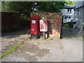
Elizabeth II postbox, Bearpark
Postbox No. DH7 42.
See Image] for context.
Image: © JThomas
Taken: 4 Jun 2016
0.04 miles
4
Aldin Grange, Bearpark
Showing position of Postbox No. DH7 42.
See Image] for postbox.
Image: © JThomas
Taken: 4 Jun 2016
0.04 miles
5
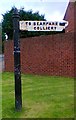
Direction Sign - Signpost by Bearpark Colliery Road, Bearpark
Mitre finial - 1 arm; by the UC road, in parish of Bearpark (Durham District), Bearpark Colliery Road (South end) at junction with Auton Stile.
Grade II listed.
List Entry Number: 1120722 https://historicengland.org.uk/listing/the-list/list-entry/1120722
To be surveyed
Milestone Society National ID: DU_NZ2443
Image: © Milestone Society
Taken: Unknown
0.05 miles
7

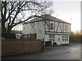
Site of Bearpark (formerly Aldin Grange) Station
View NW, towards Blackill; Lanchester Valley line (Durham - Blackhill). Called Aldin Grange until 1/5/27, this station was closed entirely on 1/5/39 when the passenger service ceased, but goods continued and the line was not closed until 20/6/66.
Image: © Ben Brooksbank
Taken: 10 May 1965
0.12 miles
8
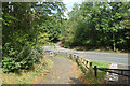
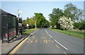
Cycleway crosses the road
Presumably there was a bridge here when the railway was working, but now the railway path drops down to cross over at road level.
Image: © Des Blenkinsopp
Taken: 23 Aug 2022
0.14 miles
9
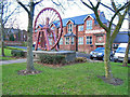
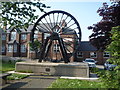
Bear Park Community Centre
Like a number of the mining villages, Bear Park has an old pit wheel installed as a memorial to its industrial past
Image: © Oliver Dixon
Taken: 3 Apr 2006
0.20 miles