IMAGES TAKEN NEAR TO
Langley Park Industrial Estate, DURHAM, DH7 6TX
Introduction
This page details the photographs taken nearby to Langley Park Industrial Estate, DH7 6TX by members of the Geograph project.
The Geograph project started in 2005 with the aim of publishing, organising and preserving representative images for every square kilometre of Great Britain, Ireland and the Isle of Man.

There are currently over 7.5m images from over14,400 individuals and you can help contribute to the project by visiting https://www.geograph.org.uk
Image Map
Images are licensed for reuse under creativecommons.org/licenses/by-sa/2.0
Notes
- Clicking on the map will re-center to the selected point.
- The higher the marker number, the further away the image location is from the centre of the postcode.
Image Listing (3 Images Found)
Images are licensed for reuse under creativecommons.org/licenses/by-sa/2.0
Image
Details
Distance
1
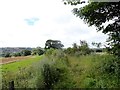
Path to Stobbilee Farm
Footpath leading south from the A691, Durham to Consett road, to Stobbilee Farm at Langley Park.
Image: © Robert Graham
Taken: 5 Aug 2015
0.23 miles
2
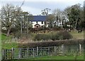
Farmhouse at Stobbilee
The house at Stobbilee Farm on the north side of Langley Park village. The farm predates the village, as it is shown on the first O S map of 1862. The village was only established in the late 19th century by Consett Iron Company as a colliery village.
Image: © Robert Graham
Taken: 21 Feb 2022
0.23 miles
3
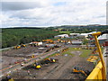
Diggerland: Excavator and dumper truck area
Image: © Roger Smith
Taken: 15 Aug 2007
0.25 miles