IMAGES TAKEN NEAR TO
Kirkwood, DURHAM, DH7 6NS
Introduction
This page details the photographs taken nearby to Kirkwood, DH7 6NS by members of the Geograph project.
The Geograph project started in 2005 with the aim of publishing, organising and preserving representative images for every square kilometre of Great Britain, Ireland and the Isle of Man.

There are currently over 7.5m images from over14,400 individuals and you can help contribute to the project by visiting https://www.geograph.org.uk
Image Map
Images are licensed for reuse under creativecommons.org/licenses/by-sa/2.0
Notes
- Clicking on the map will re-center to the selected point.
- The higher the marker number, the further away the image location is from the centre of the postcode.
Image Listing (31 Images Found)
Images are licensed for reuse under creativecommons.org/licenses/by-sa/2.0
Image
Details
Distance
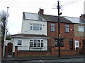
4
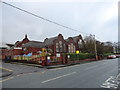
Sacriston schools
The Infant and Junior schools on Witton Road.
Image: © Robert Graham
Taken: 19 Nov 2014
0.10 miles
8
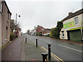
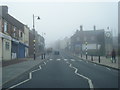
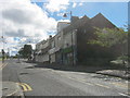
View up Front Street, Sacriston
Looking south up towards the village crossroads. Sacriston is a former mining village, typical of many in this part of County Durham.
Image: © Robert Graham
Taken: 19 Nov 2014
0.11 miles