IMAGES TAKEN NEAR TO
Errington Bungalows, DURHAM, DH7 6NE
Introduction
This page details the photographs taken nearby to Errington Bungalows, DH7 6NE by members of the Geograph project.
The Geograph project started in 2005 with the aim of publishing, organising and preserving representative images for every square kilometre of Great Britain, Ireland and the Isle of Man.

There are currently over 7.5m images from over14,400 individuals and you can help contribute to the project by visiting https://www.geograph.org.uk
Image Map (Loading...)


Getting Data...Please wait
Leaflet Map data © OpenStreetMap
Images are licensed for reuse under creativecommons.org/licenses/by-sa/2.0
Notes
- Clicking on the map will re-center to the selected point.
- The higher the marker number, the further away the image location is from the centre of the postcode.
Image Listing (31 Images Found)
Images are licensed for reuse under creativecommons.org/licenses/by-sa/2.0
Image
Details
Distance
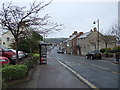
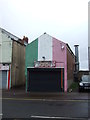
3
Five past one in Sacriston Front Street
A six metre high stainless steel artwork named Pulse
Image: © Peter Robinson
Taken: 18 Sep 2013
0.10 miles
4
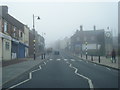
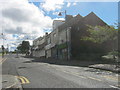
View up Front Street, Sacriston
Looking south up towards the village crossroads. Sacriston is a former mining village, typical of many in this part of County Durham.
Image: © Robert Graham
Taken: 19 Nov 2014
0.10 miles
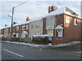
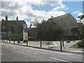
10
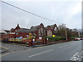
Sacriston schools
The Infant and Junior schools on Witton Road.
Image: © Robert Graham
Taken: 19 Nov 2014
0.12 miles