IMAGES TAKEN NEAR TO
Brookside, DURHAM, DH7 6JJ
Introduction
This page details the photographs taken nearby to Brookside, DH7 6JJ by members of the Geograph project.
The Geograph project started in 2005 with the aim of publishing, organising and preserving representative images for every square kilometre of Great Britain, Ireland and the Isle of Man.

There are currently over 7.5m images from over14,400 individuals and you can help contribute to the project by visiting https://www.geograph.org.uk
Image Map
Images are licensed for reuse under creativecommons.org/licenses/by-sa/2.0
Notes
- Clicking on the map will re-center to the selected point.
- The higher the marker number, the further away the image location is from the centre of the postcode.
Image Listing (3 Images Found)
Images are licensed for reuse under creativecommons.org/licenses/by-sa/2.0
Image
Details
Distance
2
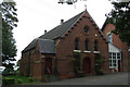
St Bede's Roman Catholic Church, Sacriston
Image: © Bill Henderson
Taken: 4 Oct 2008
0.23 miles
3
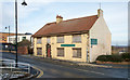
'The Village Inn', Sacriston
The closed and boarded pub is on the east side of Front Street, the B6532. It has probably been closed for some time - meals were on offer for £3.95 and there's a hole in the roof.
Image: © Trevor Littlewood
Taken: 21 Nov 2015
0.24 miles