IMAGES TAKEN NEAR TO
Edmondsley, DURHAM, DH7 6DB
Introduction
This page details the photographs taken nearby to DH7 6DB by members of the Geograph project.
The Geograph project started in 2005 with the aim of publishing, organising and preserving representative images for every square kilometre of Great Britain, Ireland and the Isle of Man.

There are currently over 7.5m images from over14,400 individuals and you can help contribute to the project by visiting https://www.geograph.org.uk
Image Map
Images are licensed for reuse under creativecommons.org/licenses/by-sa/2.0
Notes
- Clicking on the map will re-center to the selected point.
- The higher the marker number, the further away the image location is from the centre of the postcode.
Image Listing (5 Images Found)
Images are licensed for reuse under creativecommons.org/licenses/by-sa/2.0
Image
Details
Distance
1
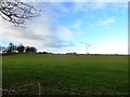
Looking towards Deneacres Farm
Looking north from the minor road between Waldridge and Edmondsley.
Image: © Robert Graham
Taken: 28 Nov 2012
0.04 miles
2
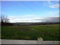
Looking north from Edmondsley
View north from the eastern edge of the village. A large part of the surrounding countryside is visible from here. Gateshead can be seen in the distance.
Image: © Robert Graham
Taken: 28 Nov 2012
0.13 miles
3
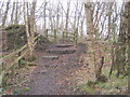
Steps for footpath to exit Waldrige Fell
Image: © Peter Robinson
Taken: 31 Mar 2013
0.13 miles
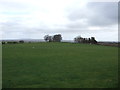
5
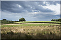
Field rising above wooded gorge
The field rises above the valley of the Cong Burn which whilst being a relatively minor feature is surprisingly steep-sided. The valley is filled with trees; the shadows of some can be seen cast immediately in front of the camera position.
Image: © Trevor Littlewood
Taken: 9 Aug 2021
0.23 miles