IMAGES TAKEN NEAR TO
Acorn Close Lane, DURHAM, DH7 6AN
Introduction
This page details the photographs taken nearby to Acorn Close Lane, DH7 6AN by members of the Geograph project.
The Geograph project started in 2005 with the aim of publishing, organising and preserving representative images for every square kilometre of Great Britain, Ireland and the Isle of Man.

There are currently over 7.5m images from over14,400 individuals and you can help contribute to the project by visiting https://www.geograph.org.uk
Image Map
Images are licensed for reuse under creativecommons.org/licenses/by-sa/2.0
Notes
- Clicking on the map will re-center to the selected point.
- The higher the marker number, the further away the image location is from the centre of the postcode.
Image Listing (5 Images Found)
Images are licensed for reuse under creativecommons.org/licenses/by-sa/2.0
Image
Details
Distance
2
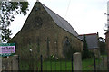
Church for Sale
St Peter's Church, Sacriston, now on the market.
Image: © Bill Henderson
Taken: 4 Oct 2008
0.21 miles
5
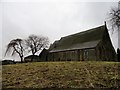
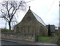
Former church in Sacriston
This was the parish church of St Peter's, built in 1866. It was replaced by a new church in 2006, better suited to modern times.
Image: © Robert Graham
Taken: 19 Nov 2014
0.24 miles