IMAGES TAKEN NEAR TO
Lanchester, DURHAM, DH7 0TF
Introduction
This page details the photographs taken nearby to DH7 0TF by members of the Geograph project.
The Geograph project started in 2005 with the aim of publishing, organising and preserving representative images for every square kilometre of Great Britain, Ireland and the Isle of Man.

There are currently over 7.5m images from over14,400 individuals and you can help contribute to the project by visiting https://www.geograph.org.uk
Image Map
Images are licensed for reuse under creativecommons.org/licenses/by-sa/2.0
Notes
- Clicking on the map will re-center to the selected point.
- The higher the marker number, the further away the image location is from the centre of the postcode.
Image Listing (3 Images Found)
Images are licensed for reuse under creativecommons.org/licenses/by-sa/2.0
Image
Details
Distance
1
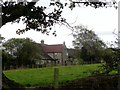
Throstle Nest Farm
This old farm is in the Browney valley, SW of Lanchester. It is shown on the 1861 First Series Ordnance Survey map. Viewed from the footpath to the east.
Image: © Robert Graham
Taken: 1 Oct 2014
0.02 miles
2
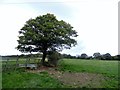
Pastureland near Throstle Nest Farm
In the countryside of the Browney valley, SW of Lanchester. Most of the land here seems to be used for sheep or cattle grazing.
Image: © Robert Graham
Taken: 1 Oct 2014
0.14 miles
3
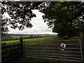
View of the Browney valley
Looking south from the footpath between Middlewood and Throstle Nest farms. Luckily for me, the bull wasn't in the field, despite the notice.
Image: © Robert Graham
Taken: 1 Oct 2014
0.16 miles