IMAGES TAKEN NEAR TO
Lanchester, DURHAM, DH7 0TE
Introduction
This page details the photographs taken nearby to DH7 0TE by members of the Geograph project.
The Geograph project started in 2005 with the aim of publishing, organising and preserving representative images for every square kilometre of Great Britain, Ireland and the Isle of Man.

There are currently over 7.5m images from over14,400 individuals and you can help contribute to the project by visiting https://www.geograph.org.uk
Image Map
Images are licensed for reuse under creativecommons.org/licenses/by-sa/2.0
Notes
- Clicking on the map will re-center to the selected point.
- The higher the marker number, the further away the image location is from the centre of the postcode.
Image Listing (7 Images Found)
Images are licensed for reuse under creativecommons.org/licenses/by-sa/2.0
Image
Details
Distance
2
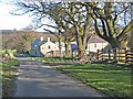
View of Broadwood Farm
Looking down the lane to the farm, with Humber Hill prominent on the horizon beyond.
Image: © Robert Graham
Taken: 16 Apr 2012
0.07 miles
4
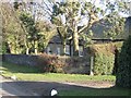
Lodge at Broadwood
Large country estate west of Lanchester. The estate buildings all date to the nineteenth century, but the hall itself was badly damanged by fire and replaced in the 1960's.
Image: © Robert Graham
Taken: 16 Apr 2012
0.08 miles
5
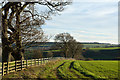
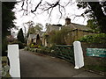
Fence descending towards River Browney
The slope and fence descend from Broadway Lane close to the collection of houses at Broadwood.
Image: © Trevor Littlewood
Taken: 2 Dec 2014
0.16 miles
6
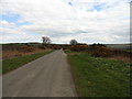
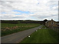
Broadwood Lane
Typical of the long straight roads in this area west of Lanchester. They were all probably put in after the Lanchester Commons Enclosure Act of 1773 divided up the previously open landscape.
Image: © Robert Graham
Taken: 16 Apr 2012
0.18 miles
7
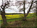
Looking south from Broadwood Lane
View over the Browney valley from east of Broadwood estate.
Image: © Robert Graham
Taken: 16 Apr 2012
0.24 miles