IMAGES TAKEN NEAR TO
Lanchester, DURHAM, DH7 0SX
Introduction
This page details the photographs taken nearby to DH7 0SX by members of the Geograph project.
The Geograph project started in 2005 with the aim of publishing, organising and preserving representative images for every square kilometre of Great Britain, Ireland and the Isle of Man.

There are currently over 7.5m images from over14,400 individuals and you can help contribute to the project by visiting https://www.geograph.org.uk
Image Map
Images are licensed for reuse under creativecommons.org/licenses/by-sa/2.0
Notes
- Clicking on the map will re-center to the selected point.
- The higher the marker number, the further away the image location is from the centre of the postcode.
Image Listing (8 Images Found)
Images are licensed for reuse under creativecommons.org/licenses/by-sa/2.0
Image
Details
Distance
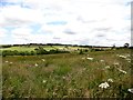
1
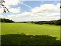
Ragpath Side Farm
View looking west from just off the lane. This farm stands in some lovely countryside west of Lanchester.
Image: © Robert Graham
Taken: 15 Jul 2015
0.01 miles
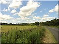
2
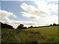
View east along the valley
This view is looking along the Browney valley from beside the road east of Lowmill Bridge. This area consists mainly of pasture grazed by sheep and cattle.
Image: © Robert Graham
Taken: 15 Jul 2015
0.13 miles
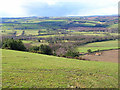
3
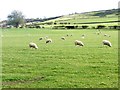
Hillside above Lowmill Bridge
Fields with sheep.
Image: © Oliver Dixon
Taken: 25 Oct 2018
0.14 miles
4
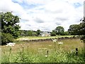
Ragpath Heath
This is a small Durham Wildlife Trust reserve west of Lanchester. View is looking north from Ragpath Lane. The farm in the distance is Hole House.
Image: © Robert Graham
Taken: 15 Jul 2015
0.15 miles
5
View up the Browney valley
Looking west from the track off Ragpath Lane up the valley. Farm in the distance is Ragpath Side.
Image: © Robert Graham
Taken: 15 Jul 2015
0.19 miles
6
View west along the lane near Ragpath Heath
Looking along this country lane west of Lanchester.
Image: © Robert Graham
Taken: 15 Jul 2015
0.20 miles
7
Valley of the River Browney
Looking north from a point just east of Cornsay village
Image: © Oliver Dixon
Taken: 3 Apr 2006
0.21 miles
8
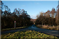
Road heading north for Partridgeclose Mill Bridge
The road descends to the valley of the River Browney. The two areas of woodland, one on each side of the road, are each small pockets of access land.
Image: © Trevor Littlewood
Taken: 9 Dec 2012
0.25 miles