
IMAGES TAKEN NEAR TO
The Paddock, DURHAM, DH7 0HW
Introduction
This page details the photographs taken nearby to The Paddock, DH7 0HW by members of the Geograph project.
The Geograph project started in 2005 with the aim of publishing, organising and preserving representative images for every square kilometre of Great Britain, Ireland and the Isle of Man.

There are currently over 7.5m images from over14,400 individuals and you can help contribute to the project by visiting https://www.geograph.org.uk
Image Map
Images are licensed for reuse under creativecommons.org/licenses/by-sa/2.0
Notes
- Clicking on the map will re-center to the selected point.
- The higher the marker number, the further away the image location is from the centre of the postcode.
Image Listing (18 Images Found)
Images are licensed for reuse under creativecommons.org/licenses/by-sa/2.0
Image
Details
Distance
1
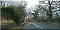
Lanchester
Entering the village on the B6301.
Image: © wfmillar
Taken: 31 Mar 2014
0.13 miles
2
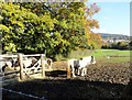
Horses in a field at Lanchester
Beside Ford Road, on the south side of the village. The housing estate on Durham Road in the background.
Image: © Robert Graham
Taken: 25 Oct 2016
0.14 miles
3
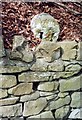
Old Milestone by the B6296, Cadger Bank, west of Lanchester
Carved stone post by the B6296, in parish of LANCHESTER (DERWENTSIDE District), Cadger Bank, above stone wall, on North West side of road. Durham numbers stone, erected by the Lobley Hill & branches turnpike trust in the 18th century.
Inscription reads:-
14
(9)
(To Newcastle and Wolsingham)
Milestone Society National ID: DU_GHWO14.
Image: © IA Davison
Taken: 1 Apr 2010
0.15 miles
4
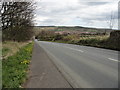
Looking down the bank to Lanchester
Looking east down Cadger Bank, the route of the B6296 leading into the village from the west.
Image: © Robert Graham
Taken: 16 Apr 2012
0.17 miles
5
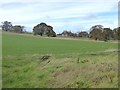
Fields south of Lanchester
Off the B6301.
Image: © Oliver Dixon
Taken: 25 Oct 2018
0.18 miles
6
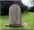
The mules of Marius
This engraved stone stands beside the Lanchester Valley Walk at the point where it crosses the B6296, near the centre of the village. It is a very accurate portrait of a 1st or 2nd century Roman legionary in full marching order. Looking at all the kit he's carrying, you can see how they acquired the mule nickname. Marius was a general who reformed the Roman army in the 1st century BC to make it a more professional force. Among other things he made the soldiers carry much of their gear instead of having a large baggage train, which slowed their mobility.
Image: © Robert Graham
Taken: 29 Jul 2016
0.18 miles
7
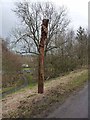
Carved pole by the Lanchester Valley Railway Path
This carved pole features a couple of creepy-crawlies and stands beside the Lanchester Valley Railway Path (National Cycle Network, route 14). This path, one of many railway paths in County Durham, follows the line of an old railway from Consett to Durham. The railway was opened in 1862, closed to passengers in 1939 and finally closed in 1965.
Image: © Oliver Dixon
Taken: 15 Mar 2013
0.18 miles
8
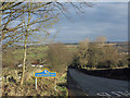
B6296 descending to Lanchester
The village of Lanchester lies at the foot of the descent apparently in the valley of the River Browney yet it's the Smallhope Burn which actually flows through the village. The blue and yellow road sign is characteristic of a style of signage introduced by County Durham some years ago.
Image: © Trevor Littlewood
Taken: 12 Dec 2012
0.19 miles
9
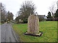
Where the legions once trod
A memorial stone commemorating the Roman links with Lanchester. Longovicium was an auxiliary fort located on Dere Street, a major Roman road running from York to Hadrian'sWall and beyond. The stone stands beside the Lanchester Valley Railway Path (National Cycle Network, route 14) one of many railway paths in County Durham, which follows the line of an old railway from Consett to Durham. The railway was opened in 1862, closed to passengers in 1939 and finally closed in 1965.
Image: © Oliver Dixon
Taken: 15 Mar 2013
0.19 miles
10
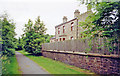
Lanchester: former station, 2000
View SE, towards Durham: ex-NER Durham - Consett/Blackhill line, closed to passengers 1/5/39, to goods 5/7/65. (Cf. Image]).
Image: © Ben Brooksbank
Taken: 20 Jun 2000
0.20 miles