IMAGES TAKEN NEAR TO
Burnhope, DURHAM, DH7 0DS
Introduction
This page details the photographs taken nearby to DH7 0DS by members of the Geograph project.
The Geograph project started in 2005 with the aim of publishing, organising and preserving representative images for every square kilometre of Great Britain, Ireland and the Isle of Man.

There are currently over 7.5m images from over14,400 individuals and you can help contribute to the project by visiting https://www.geograph.org.uk
Image Map
Images are licensed for reuse under creativecommons.org/licenses/by-sa/2.0
Notes
- Clicking on the map will re-center to the selected point.
- The higher the marker number, the further away the image location is from the centre of the postcode.
Image Listing (9 Images Found)
Images are licensed for reuse under creativecommons.org/licenses/by-sa/2.0
Image
Details
Distance

2
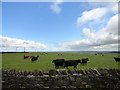
Cattle next to Newacres Road
In a field east of the road near Wheatley Hill, these are probably Aberdeen Angus beef cattle. Beyond to the left are the wind turbines on Wagtail Lane.
Image: © Robert Graham
Taken: 18 Jul 2012
0.13 miles
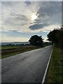
4
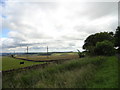
View from Newacres Road
Looking SE from a point on the road near Wheatley Hill across the fields. Sacriston woods are on the horizon to the left of centre. Good views along this section which is about 800 ft elevation.
Image: © Robert Graham
Taken: 18 Jul 2012
0.16 miles

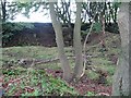
7
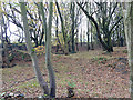
Beech wood near Wheatley Hill
The hummocky nature of the ground clearly indicates that this was an old quarry.
Image: © Oliver Dixon
Taken: 31 Oct 2014
0.18 miles

