IMAGES TAKEN NEAR TO
Barrons Way, DURHAM, DH7 0DJ
Introduction
This page details the photographs taken nearby to Barrons Way, DH7 0DJ by members of the Geograph project.
The Geograph project started in 2005 with the aim of publishing, organising and preserving representative images for every square kilometre of Great Britain, Ireland and the Isle of Man.

There are currently over 7.5m images from over14,400 individuals and you can help contribute to the project by visiting https://www.geograph.org.uk
Image Map
Images are licensed for reuse under creativecommons.org/licenses/by-sa/2.0
Notes
- Clicking on the map will re-center to the selected point.
- The higher the marker number, the further away the image location is from the centre of the postcode.
Image Listing (9 Images Found)
Images are licensed for reuse under creativecommons.org/licenses/by-sa/2.0
Image
Details
Distance
1

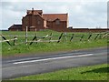
Abandoned allotments
Larger scale maps name this area of ground at Burnhope as allotments but all that's there presently is barren ground, broken wood and dilapidated sheds.
Image: © Trevor Littlewood
Taken: 19 Feb 2023
0.07 miles
2
Pavilion Terrace, Burnhope
Looking north along the main village street. This is the old part of the village, with houses dating back to the 19th century.
Image: © Robert Graham
Taken: 28 Nov 2012
0.07 miles
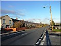
3

The main road through Burnhope
Looking southwest down Holmside Lane in this old former mining village.
Image: © Robert Graham
Taken: 28 Nov 2012
0.08 miles
5
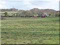
Horse paddock, Burnhope
Behind the buildings on the west side of Holmside Lane.
Image: © Christine Johnstone
Taken: 14 Apr 2012
0.18 miles
6
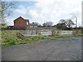
Cleared site, Holmside Lane, Burnhope
Burnhope was categorised as a "category D village" by Durham County Council. With the decline of coal-mining locally, 114 villages were classified in this way in 1951, and another seven in 1964. They were left to wither and die, without economic assistance or development. The policy ended in 1977, but many still have an old fashioned air, contrasting with newer areas of commuter housing.
Image: © Christine Johnstone
Taken: 14 Apr 2012
0.18 miles
7

Holmside Lane, Burnhope
The cricket ground is behind the wall. Burnhope was categorised as a "category D village" by Durham County Council. With the decline of coal-mining locally, 114 villages were classified in this way in 1951, and another seven in 1964. They were left to wither and die, without economic assistance or development. The policy ended in 1977, but many still have an old fashioned air, contrasting with newer areas of commuter housing.
Image: © Christine Johnstone
Taken: 14 Apr 2012
0.18 miles
8
The first and last house in Burnhope
Burnhope was categorised as a "category D village" by Durham County Council. With the decline of coal-mining locally, 114 villages were classified in this way in 1951, and another seven in 1964. They were left to wither and die, without economic assistance or development. The policy ended in 1977, but many still have an old fashioned air, contrasting with newer areas of commuter housing.
Image: © Christine Johnstone
Taken: 14 Apr 2012
0.23 miles
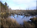
9
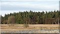
Nature reserve at Burnhope Pond
Burnhope Pond, a reserve of the Durham Wildlife Trust, with the remnants of the first snow of winter 2015/2016. The pond itself which developed as a result of mining subsidence, is hardly seen in this image.
Image: © Trevor Littlewood
Taken: 21 Nov 2015
0.24 miles