IMAGES TAKEN NEAR TO
Aged Mine Workers War Memorial Homes, DURHAM, DH6 5PA
Introduction
This page details the photographs taken nearby to Aged Mine Workers War Memorial Homes, DH6 5PA by members of the Geograph project.
The Geograph project started in 2005 with the aim of publishing, organising and preserving representative images for every square kilometre of Great Britain, Ireland and the Isle of Man.

There are currently over 7.5m images from over14,400 individuals and you can help contribute to the project by visiting https://www.geograph.org.uk
Image Map
Images are licensed for reuse under creativecommons.org/licenses/by-sa/2.0
Notes
- Clicking on the map will re-center to the selected point.
- The higher the marker number, the further away the image location is from the centre of the postcode.
Image Listing (27 Images Found)
Images are licensed for reuse under creativecommons.org/licenses/by-sa/2.0
Image
Details
Distance
1
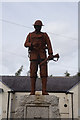
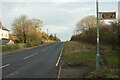
Tursdale Colliery WW1 war memorial
On Thinsford Road, Tursdale.
Image: © Ian S
Taken: 12 Sep 2020
0.01 miles
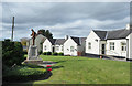
2
Tursdale Colliery WW1 war memorial
On Thinsford Road, Tursdale.
Image: © Ian S
Taken: 12 Sep 2020
0.01 miles
3
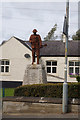
War memorial at Tursdale Colliery
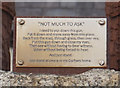
The memorial stands in front of the Aged Mine Workers War Memorial Homes. The rusted iron statue of a soldier named 'Not Much to Ask' is by Ray Lonsdale and replaces an earlier marble one, lost apparently in the 1970's, after it had been removed for renovation!
Image: © Trevor Littlewood
Taken: 9 Oct 2018
0.01 miles
4
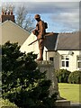
Tursdale War Memorial Sculpture
Sculpture 'Not Much To Ask' by Ray Lonsdale. The sculpture replaced an earlier stone figure that was removed in the 1970s due to damage. The new sculpture was erected and the memorial re-dedicated in 2018.
The artist's work can be found throughout the northeast, often portraying people involved in the regions historic industries.
Image: © David Robinson
Taken: 11 Feb 2023
0.01 miles
5
Tursdale Colliery WW1 war memorial
On Thinsford Road, Tursdale.
Image: © Ian S
Taken: 12 Sep 2020
0.01 miles
7
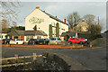
The Old Mill, Tursdale
Also shown in Image (spring) and Image (autumn); here is a view in midwinter sunshine. C19 maps show this as Thinford corn mill. "The Tursdale & Metal Bridge Working Men’s Club opened in 1920, in the former Thinford [Corn] Mill, just south of the colliery village, in Cornforth parish. After the club closed, the building opened again, as The Olde Mill Inn, in 1988" https://sites.google.com/site/bowburnlocalhistorysociety/pubs-and-clubs?mobile=true . On the right is Thinford Road. The bridge in the immediate foreground is over the Coxhoe Beck. The road to the left, which used to run past Hoggers Gate to Tursdale Colliery, has been truncated by the A688 Image
Image: © Derek Harper
Taken: 30 Dec 2019
0.06 miles
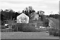
9
The Old Mill, near Tursdale
This building dates from 1813 when it opened as a paper mill; it was later also used as a corn mill. That business ceased in 1890 after which it had a variety of uses including as a pub. It is now an up-market inn with 12 en-suite rooms. In this view taken on a dismal December day the external lights are still on even though it is about 9-30am.
Image: © Stephen McKay
Taken: 23 Dec 2022
0.06 miles
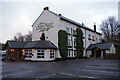
10
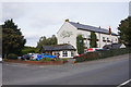
The Old Mill Public House, Thinford Road
Image: © David Dixon
Taken: 22 Mar 2016
0.06 miles