IMAGES TAKEN NEAR TO
Hett, DURHAM, DH6 5LL
Introduction
This page details the photographs taken nearby to DH6 5LL by members of the Geograph project.
The Geograph project started in 2005 with the aim of publishing, organising and preserving representative images for every square kilometre of Great Britain, Ireland and the Isle of Man.

There are currently over 7.5m images from over14,400 individuals and you can help contribute to the project by visiting https://www.geograph.org.uk
Image Map
Images are licensed for reuse under creativecommons.org/licenses/by-sa/2.0
Notes
- Clicking on the map will re-center to the selected point.
- The higher the marker number, the further away the image location is from the centre of the postcode.
Image Listing (4 Images Found)
Images are licensed for reuse under creativecommons.org/licenses/by-sa/2.0
Image
Details
Distance
1
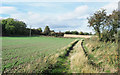
Farm road with public footpath
The road is at Broom Hill Farm which lies close by, uphill to the right in the image. It's located to the north of the small settlement at Metal Bridge.
Image: © Trevor Littlewood
Taken: 9 Oct 2018
0.09 miles
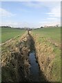
3
Farmland, Tursdale
View across fields near Tursdale, Broom Hill farm visible extreme right in the middle distance.
Image: © David Robinson
Taken: 14 May 2016
0.20 miles
4
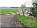
The road to Broom Hill Farm, near Hett
Image: © Oliver Dixon
Taken: 20 Apr 2006
0.23 miles