IMAGES TAKEN NEAR TO
Croxdale, DURHAM, DH6 5HF
Introduction
This page details the photographs taken nearby to DH6 5HF by members of the Geograph project.
The Geograph project started in 2005 with the aim of publishing, organising and preserving representative images for every square kilometre of Great Britain, Ireland and the Isle of Man.

There are currently over 7.5m images from over14,400 individuals and you can help contribute to the project by visiting https://www.geograph.org.uk
Image Map
Images are licensed for reuse under creativecommons.org/licenses/by-sa/2.0
Notes
- Clicking on the map will re-center to the selected point.
- The higher the marker number, the further away the image location is from the centre of the postcode.
Image Listing (48 Images Found)
Images are licensed for reuse under creativecommons.org/licenses/by-sa/2.0
Image
Details
Distance
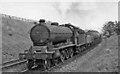
1
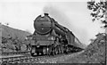
King's Cross - Newcastle express at Croxdale
View eastward, towards Ferryhill, Darlington and the South: NE ECML. Approaching the site of Croxdale station near Durham, the 09.50 from King's Cross is storming along with Gresley A3 4-6-2 No. 60075 'St Frusquin' (built as A1 No. 2574 10/24, rebuilt 6/42, withdrawn 4/63)
Image: © Ben Brooksbank
Taken: 12 Jun 1954
0.03 miles
2
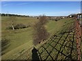
Former railway to Croxdale colliery
Site of the railway branch from the East Coast Main Line into Croxdale Colliery. The colliery closed in 1934.
Image: © David Robinson
Taken: 9 Mar 2018
0.05 miles
3
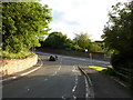
Junction of Hett Lane with the A167
Image: © Alexander P Kapp
Taken: 22 Aug 2011
0.10 miles
4
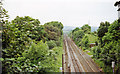
Site of Croxdale station, East Coast Main Line, 2000
View NW, towards Durham, Newcastle etc.: ex-NER ECML. No trace is left of the station, which closed on 26/9/38.
Image: © Ben Brooksbank
Taken: 20 Jun 2000
0.11 miles
7
Down ECML oil train at Croxdale
View eastward, towards Ferryhill, Darlington and the South. The train is headed by the prototype Raven S3 B16 class 4-6-0, built 12/19 as No. 840 becoming LNER No. 1400 in 1946, then BR No. 61469 in 1949 and eventually withdrawn in 10/60.
Image: © Ben Brooksbank
Taken: 12 Jun 1954
0.11 miles
8
Minor road entering Sunderland Bridge
Sunderland Bridge unsurprisingly is the name of a bridge; it's also the name of a small village, close to the bridge, and lying to the south of Durham city. The blue and yellow road sign is in a style in use in County Durham for some years.
Image: © Trevor Littlewood
Taken: 13 Jan 2015
0.11 miles
9
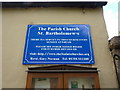
The Parish Church of St Bartholomew's, Sunderland Bridge, Sign
Image: © Alexander P Kapp
Taken: 22 Aug 2011
0.12 miles
10
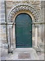
The Parish Church of St Bartholomew's, Sunderland Bridge, Doorway
Image: © Alexander P Kapp
Taken: 22 Aug 2011
0.13 miles