IMAGES TAKEN NEAR TO
Quarrington Hill, DURHAM, DH6 4RT
Introduction
This page details the photographs taken nearby to DH6 4RT by members of the Geograph project.
The Geograph project started in 2005 with the aim of publishing, organising and preserving representative images for every square kilometre of Great Britain, Ireland and the Isle of Man.

There are currently over 7.5m images from over14,400 individuals and you can help contribute to the project by visiting https://www.geograph.org.uk
Image Map
Images are licensed for reuse under creativecommons.org/licenses/by-sa/2.0
Notes
- Clicking on the map will re-center to the selected point.
- The higher the marker number, the further away the image location is from the centre of the postcode.
Image Listing (2 Images Found)
Images are licensed for reuse under creativecommons.org/licenses/by-sa/2.0
Image
Details
Distance
1
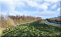
Grassy slope rising to birch woodland
The grass, trees and the road all appear to be within the Crow Trees Nature Reserve, close to the village of Quarrington Hill. The reserve is important for its magnesian limestone grassland.
The surrounding area has been extensively quarried and mined in the past and extraction continues at Tarmac's Quarrington Quarry to the north of the reserve.
Image: © Trevor Littlewood
Taken: 7 Jan 2022
0.21 miles
2
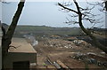
Coxhoe Tip
The site of a former limestone quarry, now a landfill site and recycling centre.
Image: © David Robinson
Taken: 13 Dec 2004
0.24 miles