IMAGES TAKEN NEAR TO
Cassop, DURHAM, DH6 4RB
Introduction
This page details the photographs taken nearby to DH6 4RB by members of the Geograph project.
The Geograph project started in 2005 with the aim of publishing, organising and preserving representative images for every square kilometre of Great Britain, Ireland and the Isle of Man.

There are currently over 7.5m images from over14,400 individuals and you can help contribute to the project by visiting https://www.geograph.org.uk
Image Map
Images are licensed for reuse under creativecommons.org/licenses/by-sa/2.0
Notes
- Clicking on the map will re-center to the selected point.
- The higher the marker number, the further away the image location is from the centre of the postcode.
Image Listing (10 Images Found)
Images are licensed for reuse under creativecommons.org/licenses/by-sa/2.0
Image
Details
Distance
2
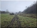
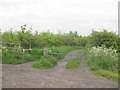
Public Footpath to Cassop Hill and beyond
Image: © Peter Robinson
Taken: 10 Jun 2012
0.13 miles
4
Entrance to Little Wood Nature Reserve from Quarrington Hill Road
Image: © Peter Robinson
Taken: 10 Jun 2012
0.16 miles
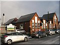
5
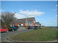
County Primary School, Quarrington Hill
Image: © Bill Henderson
Taken: 9 Mar 2007
0.16 miles
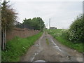
6
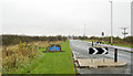
Traffic calming at Cassop
Vehicles approaching the village of Cassop from the south-west by the B6291 are required to make turns through a small chicane. Vehicles leaving the village that way have to make the same manoeuvre but additionally must give way to incoming traffic. One of those County Durham, blue and yellow road signs is in the image too.
Image: © Trevor Littlewood
Taken: 29 Oct 2015
0.17 miles
7
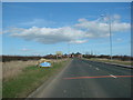
Entering Cassop on the B6291 from Quarrington Hill
Image: © Bill Henderson
Taken: 9 Mar 2007
0.17 miles
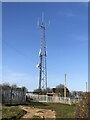
8
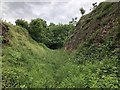
Old Waggonway, Quarrington Hill
The Magnesian Limestone in this area has been heavily quarried, while the underlying coal seams have also been extensively worked. The early 19th Century mines and quarries produced a network of local waggonways and inclines connecting the various workings with the network of waggonways and early railways distributing the produce. Many of these have left scars across the finger of Limestone that separates Quarrington and Cassop vale, such as the cutting seen here.
Image: © David Robinson
Taken: 13 Jun 2018
0.19 miles
9
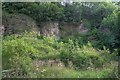
Former Limestone Quarry
Magnesian limestone was the reason for the quarry and it is now the reason why the Cassop Vale has been designated a National Nature Reserve. The thin lime rich soils encourages rare plants such as blue moor grass, rock-rose and bird's eye primrose.
Image: © Mick Garratt
Taken: 21 Jul 2008
0.20 miles