IMAGES TAKEN NEAR TO
Bradyll Street, DURHAM, DH6 4PL
Introduction
This page details the photographs taken nearby to Bradyll Street, DH6 4PL by members of the Geograph project.
The Geograph project started in 2005 with the aim of publishing, organising and preserving representative images for every square kilometre of Great Britain, Ireland and the Isle of Man.

There are currently over 7.5m images from over14,400 individuals and you can help contribute to the project by visiting https://www.geograph.org.uk
Image Map
Images are licensed for reuse under creativecommons.org/licenses/by-sa/2.0
Notes
- Clicking on the map will re-center to the selected point.
- The higher the marker number, the further away the image location is from the centre of the postcode.
Image Listing (8 Images Found)
Images are licensed for reuse under creativecommons.org/licenses/by-sa/2.0
Image
Details
Distance
1
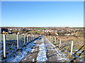
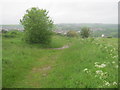
Rough road rising towards Raisby Quarries
There now seems to be a single massive excavation at Raisby quarries - perhaps the plural name came from the amalgamation of a number of lesser workings. The road is probably no longer used as an access route for any of the workings; it's marked on OS maps as an 'other route with public access'.
The village of Kelloe accounts for most of the built-up area in the distance.
Image: © Trevor Littlewood
Taken: 17 Jan 2019
0.04 miles
5
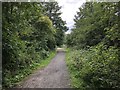
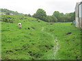
The Kelloe Way
The former mineral railway branch line to East Hetton (Kelloe) Colliery, now a recreational route named the Kelloe Way. View looking West from the edge of Kelloe with barriers marking the point where a minor road to a sewerage plant crosses the Kelloe Way.
Image: © David Robinson
Taken: 17 Jul 2019
0.14 miles
6
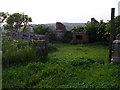
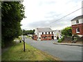
Footpath to Kelloe from Raisby Quarry
Image: © Peter Robinson
Taken: 10 Jun 2012
0.19 miles
8
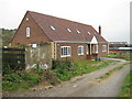
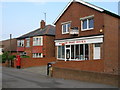
The Davy Lamp at Kelloe
A pub of this name is shown on the first Ordnance Survey map of the 1860's, but this particular building looks much later than that.
Image: © Robert Graham
Taken: 19 Jun 2013
0.24 miles