IMAGES TAKEN NEAR TO
Petterson Dale, DURHAM, DH6 4HA
Introduction
This page details the photographs taken nearby to Petterson Dale, DH6 4HA by members of the Geograph project.
The Geograph project started in 2005 with the aim of publishing, organising and preserving representative images for every square kilometre of Great Britain, Ireland and the Isle of Man.

There are currently over 7.5m images from over14,400 individuals and you can help contribute to the project by visiting https://www.geograph.org.uk
Image Map
Images are licensed for reuse under creativecommons.org/licenses/by-sa/2.0
Notes
- Clicking on the map will re-center to the selected point.
- The higher the marker number, the further away the image location is from the centre of the postcode.
Image Listing (26 Images Found)
Images are licensed for reuse under creativecommons.org/licenses/by-sa/2.0
Image
Details
Distance
3
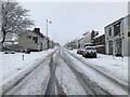
Coxhoe In Winter's Grip
Coxhoe village centre after a period of heavy snowfall.
Image: © David Robinson
Taken: 8 Jan 2021
0.08 miles
5
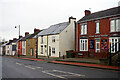
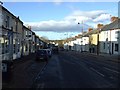
Front Street East, Coxhoe
Street names in Coxhoe are confusing. In this view the houses are on Front Street East, but the dental practice gives its address as Blackgate East. Presumably their 'west' equivalents are on the opposite side but those names don't seem to be used. In any case this is a stretch of the B6291. Modern Coxhoe is a product of the development of the Durham coalfield in the late 18th and early 19th centuries and has an unremittingly workaday feel about it.
Image: © Stephen McKay
Taken: 23 Dec 2022
0.08 miles
6
St Mary's church, Coxhoe
The parish church for the village.
Image: © Robert Graham
Taken: 19 Jun 2013
0.08 miles
7
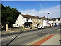
Village shops in Coxhoe
Coxhoe seems to have a decent amount of shops, in contrast to many villages. These are on the main street, the B6291.
Image: © Robert Graham
Taken: 19 Jun 2013
0.08 miles
8

Looking north from Coxhoe bank top
View down the main street, the B6291.
Image: © Robert Graham
Taken: 19 Jun 2013
0.08 miles
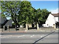
9
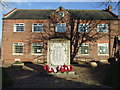
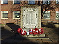
Coxhoe Social and Literary Institute and Village Hall
Image: © Oliver Dixon
Taken: 20 Apr 2006
0.08 miles
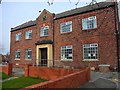
10
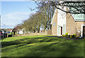
St. Joseph's RC. Church with lawn
The modern church of St. Joseph in the village of Coxhoe.
The wheel in the distance is from an old colliery winding system, they're commonly displayed in old mining villages.
Image: © Trevor Littlewood
Taken: 7 Jan 2022
0.09 miles