IMAGES TAKEN NEAR TO
Thinford Road, DURHAM, DH6 4EU
Introduction
This page details the photographs taken nearby to Thinford Road, DH6 4EU by members of the Geograph project.
The Geograph project started in 2005 with the aim of publishing, organising and preserving representative images for every square kilometre of Great Britain, Ireland and the Isle of Man.

There are currently over 7.5m images from over14,400 individuals and you can help contribute to the project by visiting https://www.geograph.org.uk
Image Map
Images are licensed for reuse under creativecommons.org/licenses/by-sa/2.0
Notes
- Clicking on the map will re-center to the selected point.
- The higher the marker number, the further away the image location is from the centre of the postcode.
Image Listing (6 Images Found)
Images are licensed for reuse under creativecommons.org/licenses/by-sa/2.0
Image
Details
Distance
1
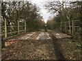
Old bridge deck near Coxhoe
Remains of a bridge deck carrying the railway over a farm track / footpath near Coxhoe. This was the Coxhoe branch of the Clarence Railway, a Pre-Victorian early railway and competitor to the Stockton & Darlington Railway taking coals from the Durham coalfields to the Tees for shipment. The branch served early collieries in the Coxhoe area. In later years the line served a large lime works at Coxhoe until the early 1980s.
Image: © David Robinson
Taken: 21 Jan 2019
0.12 miles