IMAGES TAKEN NEAR TO
The Grove, DURHAM, DH6 4AP
Introduction
This page details the photographs taken nearby to The Grove, DH6 4AP by members of the Geograph project.
The Geograph project started in 2005 with the aim of publishing, organising and preserving representative images for every square kilometre of Great Britain, Ireland and the Isle of Man.

There are currently over 7.5m images from over14,400 individuals and you can help contribute to the project by visiting https://www.geograph.org.uk
Image Map
Images are licensed for reuse under creativecommons.org/licenses/by-sa/2.0
Notes
- Clicking on the map will re-center to the selected point.
- The higher the marker number, the further away the image location is from the centre of the postcode.
Image Listing (9 Images Found)
Images are licensed for reuse under creativecommons.org/licenses/by-sa/2.0
Image
Details
Distance
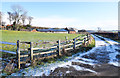
2
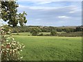
View over farmland to the SE of Coxhoe
Image: © David Robinson
Taken: 11 Sep 2018
0.22 miles
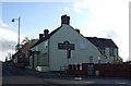
3
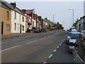
The Avenue (B6291) towards Roman Road in Coxhoe
Image: © Peter Robinson
Taken: 10 Jun 2012
0.22 miles
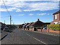
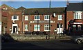
5
Buildings at Avenue Farm
Avenue Farm lies at the eastern side of Coxhoe, below the B6291.
Image: © Trevor Littlewood
Taken: 17 Jan 2019
0.24 miles
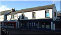
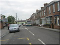
9
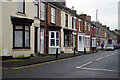
Cornforth Lane, Coxhoe
This row of houses is called Cooperative Terrace and although each dwelling is similar they all have detailed differences. Those with plain brickwork arguably look better than the ones with rendered walls.
Image: © Stephen McKay
Taken: 23 Dec 2022
0.25 miles