IMAGES TAKEN NEAR TO
Thornley, DURHAM, DH6 3HS
Introduction
This page details the photographs taken nearby to DH6 3HS by members of the Geograph project.
The Geograph project started in 2005 with the aim of publishing, organising and preserving representative images for every square kilometre of Great Britain, Ireland and the Isle of Man.

There are currently over 7.5m images from over14,400 individuals and you can help contribute to the project by visiting https://www.geograph.org.uk
Image Map
Images are licensed for reuse under creativecommons.org/licenses/by-sa/2.0
Notes
- Clicking on the map will re-center to the selected point.
- The higher the marker number, the further away the image location is from the centre of the postcode.
Image Listing (4 Images Found)
Images are licensed for reuse under creativecommons.org/licenses/by-sa/2.0
Image
Details
Distance
2
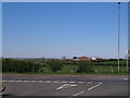
From the A181 towards High Croft House and the windfarm
Image: © John Slater
Taken: 27 May 2012
0.17 miles
3
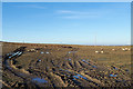
Earthen field with grazing sheep
The partly rutted field on the north side of the A181 appears to be devoid of anything of food value to the sheep but closer inspection reveals that the soil is tinged with green - there are low plants growing.
Image: © Trevor Littlewood
Taken: 20 Jan 2020
0.20 miles