IMAGES TAKEN NEAR TO
Brackenridge, DURHAM, DH6 2QT
Introduction
This page details the photographs taken nearby to Brackenridge, DH6 2QT by members of the Geograph project.
The Geograph project started in 2005 with the aim of publishing, organising and preserving representative images for every square kilometre of Great Britain, Ireland and the Isle of Man.

There are currently over 7.5m images from over14,400 individuals and you can help contribute to the project by visiting https://www.geograph.org.uk
Image Map
Images are licensed for reuse under creativecommons.org/licenses/by-sa/2.0
Notes
- Clicking on the map will re-center to the selected point.
- The higher the marker number, the further away the image location is from the centre of the postcode.
Image Listing (5 Images Found)
Images are licensed for reuse under creativecommons.org/licenses/by-sa/2.0
Image
Details
Distance
1
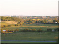
Evening From The Airstrip
This is the view from the footpath at the end of Shotton Airfield. The grid square begins at the first tree line.
Image: © Colin Keightley
Taken: 29 May 2005
0.12 miles
3
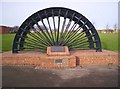
Memorial Pit Wheel Shotton Colliery
Pit wheel with names of miners killed in the pit at Shotton Colliery
Image: © Barry Wood
Taken: 19 Jan 2008
0.14 miles