IMAGES TAKEN NEAR TO
Church Wynd, DURHAM, DH6 1QU
Introduction
This page details the photographs taken nearby to Church Wynd, DH6 1QU by members of the Geograph project.
The Geograph project started in 2005 with the aim of publishing, organising and preserving representative images for every square kilometre of Great Britain, Ireland and the Isle of Man.

There are currently over 7.5m images from over14,400 individuals and you can help contribute to the project by visiting https://www.geograph.org.uk
Image Map
Images are licensed for reuse under creativecommons.org/licenses/by-sa/2.0
Notes
- Clicking on the map will re-center to the selected point.
- The higher the marker number, the further away the image location is from the centre of the postcode.
Image Listing (32 Images Found)
Images are licensed for reuse under creativecommons.org/licenses/by-sa/2.0
Image
Details
Distance
1
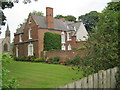
Vicarage for the Church of St Mary in Sherburn
Image: © Peter Robinson
Taken: 31 Jul 2011
0.02 miles
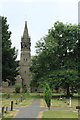
2
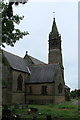
Sherburn Parish Church
The parish church viewed looking east.
Image: © edward mcmaihin
Taken: 20 Jul 2013
0.06 miles
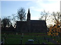
4
Sherburn Parish Church
The Parish Church viewed from inside the cemetery.
Image: © edward mcmaihin
Taken: 20 Jul 2013
0.06 miles
5
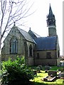
Church of St Mary The Virgin, Sherburn
Image: © Bill Henderson
Taken: 9 Mar 2007
0.06 miles
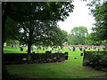
6
Sherburn Parish Church Churchyard
The Churchyard located to the rear of the church.
Image: © edward mcmaihin
Taken: 20 Jul 2013
0.07 miles
7
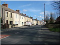
Sherburn Community Centre
Community Centre in Sherburn located close to the cross roads.
Image: © edward mcmaihin
Taken: 20 Jul 2013
0.08 miles
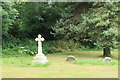
8
Churchyard at St Mary's Church Sherburn
Image: © Peter Robinson
Taken: 12 Jul 2011
0.09 miles
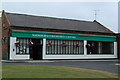
9
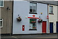
Post Office Sherburn
The Post Office in Sherburn.
Image: © edward mcmaihin
Taken: 20 Jul 2013
0.09 miles