IMAGES TAKEN NEAR TO
Brighton Terrace, DURHAM, DH6 1PE
Introduction
This page details the photographs taken nearby to Brighton Terrace, DH6 1PE by members of the Geograph project.
The Geograph project started in 2005 with the aim of publishing, organising and preserving representative images for every square kilometre of Great Britain, Ireland and the Isle of Man.

There are currently over 7.5m images from over14,400 individuals and you can help contribute to the project by visiting https://www.geograph.org.uk
Image Map
Images are licensed for reuse under creativecommons.org/licenses/by-sa/2.0
Notes
- Clicking on the map will re-center to the selected point.
- The higher the marker number, the further away the image location is from the centre of the postcode.
Image Listing (14 Images Found)
Images are licensed for reuse under creativecommons.org/licenses/by-sa/2.0
Image
Details
Distance
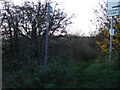
2
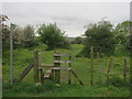
Stile in Sherburn Hill for footpath to Shadforth
Image: © Peter Robinson
Taken: 3 Jun 2012
0.05 miles
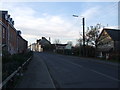
4
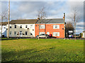
Houses in Sherburn Hill
Houses on the north side of the B1283 seen from a public footpath over a grassed area on the road's south side.
Image: © Trevor Littlewood
Taken: 25 Jan 2019
0.08 miles
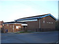
5
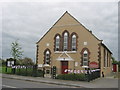
Methodist Chapel in Sherburn Hill
Erected in 1851 and enlarged in 1902
Image: © Peter Robinson
Taken: 3 Jun 2012
0.08 miles
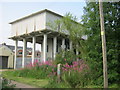
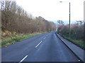
9
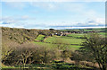
Wooded slope below Sherburn Hill
Sherburn Hill is a small village lying to the east of the larger Sherburn, and on a hill. The view is from the south side of the village across an arc of woodland on a steep slope.
The village at the end of the woodland is Shadforth.
Image: © Trevor Littlewood
Taken: 25 Jan 2019
0.12 miles