IMAGES TAKEN NEAR TO
Springfield Meadow, DURHAM, DH6 1NY
Introduction
This page details the photographs taken nearby to Springfield Meadow, DH6 1NY by members of the Geograph project.
The Geograph project started in 2005 with the aim of publishing, organising and preserving representative images for every square kilometre of Great Britain, Ireland and the Isle of Man.

There are currently over 7.5m images from over14,400 individuals and you can help contribute to the project by visiting https://www.geograph.org.uk
Image Map (Loading...)


Getting Data...Please wait
Leaflet Map data © OpenStreetMap
Images are licensed for reuse under creativecommons.org/licenses/by-sa/2.0
Notes
- Clicking on the map will re-center to the selected point.
- The higher the marker number, the further away the image location is from the centre of the postcode.
Image Listing (17 Images Found)
Images are licensed for reuse under creativecommons.org/licenses/by-sa/2.0
Image
Details
Distance
1
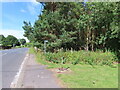
Public footpath into woods, Ludworth
Ludworth school was near here.
Image: © David Hawgood
Taken: 7 Aug 2022
0.14 miles
2
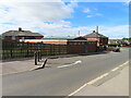
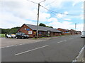
Commercial printing works, Ludworth
The premises of Whitesprint.
Image: © David Hawgood
Taken: 7 Aug 2022
0.14 miles
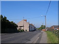
3
Main street in Ludworth
Looking East along the street.
Image: © Robert Graham
Taken: 12 Jul 2011
0.15 miles
4
The northern end of Moor Crescent in Ludworth
Image: © Peter Robinson
Taken: 2 Sep 2012
0.15 miles
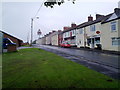
5
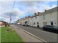
North View, Margaret Street, Ludworth
The same view as Image taken in 2011. What was then the post office has become a private house, but the wall letter box remains in the same place. The shop next door is now also the post office. When Ludworth Colliery was active this terrace had three pubs and a post office. The community centre is seen on the left.
Image: © David Hawgood
Taken: 6 Aug 2022
0.15 miles
6
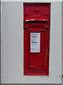
GR wall letter box, Ludworth
It is in the wall of the former post office, next door to the present post office.
Image: © David Hawgood
Taken: 6 Aug 2022
0.15 miles
7
Ludworth community centre
In the former pit village.
Image: © David Hawgood
Taken: 6 Aug 2022
0.17 miles
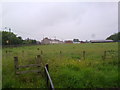
8
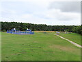
Ludworth playing field, formerly miners' housing area
On the 25 inch OS map published 1919 it has rows of miners' houses on Victoria, Albert, Alexandra, Mary, Edward and George Streets. This area has a fenced basketball court on site of Alexandra Street, another basketball hoop on site of George Street, and off to the right a football field.
Image: © David Hawgood
Taken: 6 Aug 2022
0.18 miles
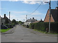
10
Approaching Ludworth from the East
Viewed from just before the crossroads.
Image: © Robert Graham
Taken: 12 Jul 2011
0.20 miles