IMAGES TAKEN NEAR TO
Shadforth, DURHAM, DH6 1NJ
Introduction
This page details the photographs taken nearby to DH6 1NJ by members of the Geograph project.
The Geograph project started in 2005 with the aim of publishing, organising and preserving representative images for every square kilometre of Great Britain, Ireland and the Isle of Man.

There are currently over 7.5m images from over14,400 individuals and you can help contribute to the project by visiting https://www.geograph.org.uk
Image Map
Images are licensed for reuse under creativecommons.org/licenses/by-sa/2.0
Notes
- Clicking on the map will re-center to the selected point.
- The higher the marker number, the further away the image location is from the centre of the postcode.
Image Listing (8 Images Found)
Images are licensed for reuse under creativecommons.org/licenses/by-sa/2.0
Image
Details
Distance
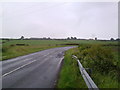
1

Road junction near Shadforth
Looking East down the road towards Shadforth.
Image: © Robert Graham
Taken: 12 Jul 2011
0.05 miles


8
View from the road between Ludworth and Shadforth
Looking South. The farm on the horizon is Ox Close in square NZ3540.
Image: © Robert Graham
Taken: 12 Jul 2011
0.18 miles