IMAGES TAKEN NEAR TO
Coalford Road, DURHAM, DH6 1JL
Introduction
This page details the photographs taken nearby to Coalford Road, DH6 1JL by members of the Geograph project.
The Geograph project started in 2005 with the aim of publishing, organising and preserving representative images for every square kilometre of Great Britain, Ireland and the Isle of Man.

There are currently over 7.5m images from over14,400 individuals and you can help contribute to the project by visiting https://www.geograph.org.uk
Image Map
Images are licensed for reuse under creativecommons.org/licenses/by-sa/2.0
Notes
- Clicking on the map will re-center to the selected point.
- The higher the marker number, the further away the image location is from the centre of the postcode.
Image Listing (6 Images Found)
Images are licensed for reuse under creativecommons.org/licenses/by-sa/2.0
Image
Details
Distance
2

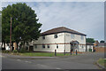
Lambton Field, Sherburn
New housing on the edge of the village.
Image: © Des Blenkinsopp
Taken: 28 Aug 2022
0.09 miles
3
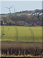
Sherburn from the west
Looking towards the village from the A181/B1283 junction
Image: © Paul Harrop
Taken: 16 Feb 2014
0.20 miles
4
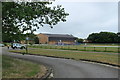
Sherburn Village Park
The road into the village park and car park.
Image: © edward mcmaihin
Taken: 20 Jul 2013
0.21 miles
5
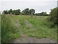
Field gate from the road north of Sherburn
Image: © Peter Robinson
Taken: 12 Jul 2011
0.23 miles
6

Sherburn Village Industrial Estate
Small industrial estate in Sherburn.
Image: © edward mcmaihin
Taken: 20 Jul 2013
0.24 miles