IMAGES TAKEN NEAR TO
Liddle Avenue, DURHAM, DH6 1HZ
Introduction
This page details the photographs taken nearby to Liddle Avenue, DH6 1HZ by members of the Geograph project.
The Geograph project started in 2005 with the aim of publishing, organising and preserving representative images for every square kilometre of Great Britain, Ireland and the Isle of Man.

There are currently over 7.5m images from over14,400 individuals and you can help contribute to the project by visiting https://www.geograph.org.uk
Image Map
Images are licensed for reuse under creativecommons.org/licenses/by-sa/2.0
Notes
- Clicking on the map will re-center to the selected point.
- The higher the marker number, the further away the image location is from the centre of the postcode.
Image Listing (32 Images Found)
Images are licensed for reuse under creativecommons.org/licenses/by-sa/2.0
Image
Details
Distance
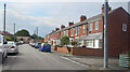
1

Public footpath on lane behind Front Street in Sherburn
Image: © Peter Robinson
Taken: 31 Jul 2011
0.10 miles
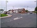
2

The Lambton Arms, Sherburn
Sherburn is a former pit village, not far from Durham City.
Image: © Uncredited
Taken: 3 Dec 2003
0.11 miles
3
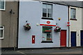
Post Office Sherburn
The Post Office in Sherburn.
Image: © edward mcmaihin
Taken: 20 Jul 2013
0.12 miles
4
Front Street Sherburn
Front Street in Sherburn.
Image: © edward mcmaihin
Taken: 20 Jul 2013
0.12 miles
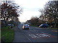
5
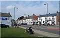
Front Street, Sherburn
The centre of the village, with the Lambton Arms pub across the road.
Image: © Des Blenkinsopp
Taken: 28 Aug 2022
0.13 miles
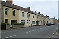
6
Nelson Terrace, Sherburn
Terraced housing on Park House Gardens.
Image: © Des Blenkinsopp
Taken: 28 Aug 2022
0.14 miles
8
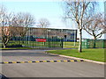
Sherburn County Primary and Infants School
Image: © Oliver Dixon
Taken: 10 Apr 2006
0.15 miles
10
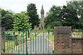
Sherburn Cemetery
The gates to Sherburn Cemetery.
Image: © edward mcmaihin
Taken: 20 Jul 2013
0.16 miles