IMAGES TAKEN NEAR TO
Wesley Terrace, DURHAM, DH6 1HL
Introduction
This page details the photographs taken nearby to Wesley Terrace, DH6 1HL by members of the Geograph project.
The Geograph project started in 2005 with the aim of publishing, organising and preserving representative images for every square kilometre of Great Britain, Ireland and the Isle of Man.

There are currently over 7.5m images from over14,400 individuals and you can help contribute to the project by visiting https://www.geograph.org.uk
Image Map
Images are licensed for reuse under creativecommons.org/licenses/by-sa/2.0
Notes
- Clicking on the map will re-center to the selected point.
- The higher the marker number, the further away the image location is from the centre of the postcode.
Image Listing (7 Images Found)
Images are licensed for reuse under creativecommons.org/licenses/by-sa/2.0
Image
Details
Distance
1
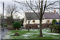
Grassed area with house beyond
The grass is on the north side of the B1283 passing through the village of Sherburn Hill.
Image: © Trevor Littlewood
Taken: 13 Jan 2017
0.07 miles
2

Sherburn Hill
One of the many former colliery villages in the Durham coalfield, the colliery at Sherburn Hill operated until 1965. As the name suggests the village is situated on a hillside and has views towards Durham City with its large cathedral.
Image: © David Robinson
Taken: 11 Oct 2018
0.07 miles
3
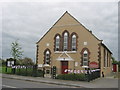
Methodist Chapel in Sherburn Hill
Erected in 1851 and enlarged in 1902
Image: © Peter Robinson
Taken: 3 Jun 2012
0.17 miles
4
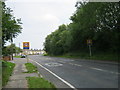
Road from the west up to Sherburn Hill Village
Image: © Peter Robinson
Taken: 31 Jul 2011
0.18 miles
6
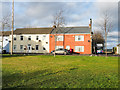
Houses in Sherburn Hill
Houses on the north side of the B1283 seen from a public footpath over a grassed area on the road's south side.
Image: © Trevor Littlewood
Taken: 25 Jan 2019
0.18 miles
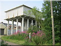
7
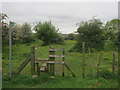
Stile in Sherburn Hill for footpath to Shadforth
Image: © Peter Robinson
Taken: 3 Jun 2012
0.20 miles