IMAGES TAKEN NEAR TO
High Pittington, DURHAM, DH6 1EY
Introduction
This page details the photographs taken nearby to DH6 1EY by members of the Geograph project.
The Geograph project started in 2005 with the aim of publishing, organising and preserving representative images for every square kilometre of Great Britain, Ireland and the Isle of Man.

There are currently over 7.5m images from over14,400 individuals and you can help contribute to the project by visiting https://www.geograph.org.uk
Image Map
Images are licensed for reuse under creativecommons.org/licenses/by-sa/2.0
Notes
- Clicking on the map will re-center to the selected point.
- The higher the marker number, the further away the image location is from the centre of the postcode.
Image Listing (6 Images Found)
Images are licensed for reuse under creativecommons.org/licenses/by-sa/2.0
Image
Details
Distance
1
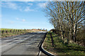
Minor road north-east of Pittington Bridge
The road connects the villages of Sherburn and High Pittington and is rising from Pittington Bridge heading towards the latter village.
Image: © Trevor Littlewood
Taken: 2 Mar 2017
0.16 miles
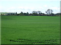
4
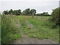
Hedgerow and fields, Hallgarth
Looking south.
Image: © JThomas
Taken: 28 May 2015
0.22 miles
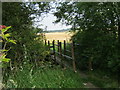
5
Field gate from the road north of Sherburn
Image: © Peter Robinson
Taken: 12 Jul 2011
0.23 miles
6
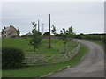
Drive to Broomside House just north of Sherburn
Image: © Peter Robinson
Taken: 12 Jul 2011
0.24 miles