IMAGES TAKEN NEAR TO
West Rainton, HOUGHTON LE SPRING, DH5 9RH
Introduction
This page details the photographs taken nearby to DH5 9RH by members of the Geograph project.
The Geograph project started in 2005 with the aim of publishing, organising and preserving representative images for every square kilometre of Great Britain, Ireland and the Isle of Man.

There are currently over 7.5m images from over14,400 individuals and you can help contribute to the project by visiting https://www.geograph.org.uk
Image Map
Images are licensed for reuse under creativecommons.org/licenses/by-sa/2.0
Notes
- Clicking on the map will re-center to the selected point.
- The higher the marker number, the further away the image location is from the centre of the postcode.
Image Listing (7 Images Found)
Images are licensed for reuse under creativecommons.org/licenses/by-sa/2.0
Image
Details
Distance
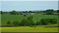
2
Mixed farmland west of High Moorsley
Image: © GRAEME and LESLEY CRANSTON
Taken: 23 Sep 2006
0.08 miles
3
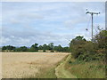
Public footpath near West Rainton
A public footpath along the side of a field near West Rainton in County Durham.
Image: © Malc McDonald
Taken: 28 Aug 2011
0.11 miles
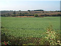
5
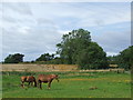
Horses near West Rainton
Horses grazing in a field near West Rainton, County Durham.
Image: © Malc McDonald
Taken: 28 Aug 2011
0.18 miles
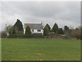
6

Farm track near West Rainton
A track leading to Field House Farm, near West Rainton in County Durham.
Image: © Malc McDonald
Taken: 28 Aug 2011
0.23 miles
7
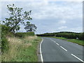
Robin Lane near West Rainton
A country road near West Rainton in County Durham.
Image: © Malc McDonald
Taken: 28 Aug 2011
0.23 miles