IMAGES TAKEN NEAR TO
School Road, HOUGHTON LE SPRING, DH5 9QW
Introduction
This page details the photographs taken nearby to School Road, DH5 9QW by members of the Geograph project.
The Geograph project started in 2005 with the aim of publishing, organising and preserving representative images for every square kilometre of Great Britain, Ireland and the Isle of Man.

There are currently over 7.5m images from over14,400 individuals and you can help contribute to the project by visiting https://www.geograph.org.uk
Image Map
Images are licensed for reuse under creativecommons.org/licenses/by-sa/2.0
Notes
- Clicking on the map will re-center to the selected point.
- The higher the marker number, the further away the image location is from the centre of the postcode.
Image Listing (22 Images Found)
Images are licensed for reuse under creativecommons.org/licenses/by-sa/2.0
Image
Details
Distance
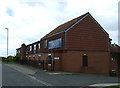
1
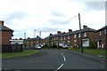
Cowley Crescent, East Rainton
Off Durham Road.
Image: © JThomas
Taken: 28 May 2015
0.05 miles
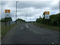
2

Durham Road, East Rainton
Heading north east.
Image: © JThomas
Taken: 28 May 2015
0.07 miles
4
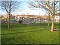
Playground, East Rainton
Set in a large open space on Quarry House Lane.
Image: © Oliver Dixon
Taken: 16 Jan 2007
0.15 miles
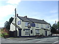
6
The Highfield Hotel, East Rainton
On Durham Road.
Image: © JThomas
Taken: 28 May 2015
0.16 miles
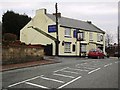
7
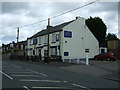
The Olde Ships Inn, East Rainton
On Durham Road.
Image: © JThomas
Taken: 28 May 2015
0.18 miles
8
The Olde Ships Inn, East Rainton
The Olde Ships Inn in the village of East Rainton.
Image: © Malc McDonald
Taken: 28 Aug 2011
0.19 miles
9
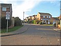
Bloomfield Drive, East Rainton
Typical of the many modern housing estates growing up round the old colliery villages of County Durham.
Image: © Oliver Dixon
Taken: 16 Jan 2007
0.19 miles
10
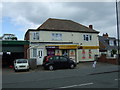
Convenience store, East Rainton
On Durham Road.
Image: © JThomas
Taken: 28 May 2015
0.19 miles